CARTA DE NAVEGACIÓN COSTERA

Taxonomía

Código

Nota(s) sobre el alcance

Nota(s) sobre el origen

Mostrar nota(s)

Términos jerárquicos

CARTA DE NAVEGACIÓN COSTERA

Términos equivalentes

CARTA DE NAVEGACIÓN COSTERA

Términos asociados

CARTA DE NAVEGACIÓN COSTERA

118 Descripción archivística results for CARTA DE NAVEGACIÓN COSTERA

Sólo resultados directamente relacionados

NORTH COAST OF PUERTO RICO. PUNTA PEÑON TO PUNTA VACÍA TALEGA

  • ES EXPONAV CARTAS NÁUTICAS CCN-000284
  • Unidad documental simple
  • 1952
  • Parte deCARTAS NÁUTICAS

Zona Geográfica: Indias Occidentales
Aparece la ciudad de San Juan en Puerto Rico. Incluye dos recuadros: Puerto Palmas Altas a 1:10000 y Puerto Arecibo a 1:20000

INSTITUTO HIDROGRÁFICO ESTADOS UNIDOS DE AMÉRICA

ORKNEY ISLANDS

  • ES EXPONAV CARTAS NÁUTICAS CCN-000163
  • Unidad documental simple
  • 1850
  • Parte deCARTAS NÁUTICAS

Zona Geográfica: Escocia. Islas Orcadas
Aparecen las islas Orcadas en la costa norte de Escocia.

INSTITUTO HIDROGRÁFICO INGLATERRA

OSLA FJORD

  • ES EXPONAV CARTAS NÁUTICAS CCN-000173
  • Unidad documental simple
  • 1916
  • Parte deCARTAS NÁUTICAS

Zona Geográfica: Costa sur de Noruega
Aparece la península Nessoden, Hurum landet.
Contiene un recuadro con Ide Fjord

INSTITUTO HIDROFRÁFICO NORUEGA

PLANS EN THE ARQUIPÉLAGO DOS AÇORES

  • ES EXPONAV CARTAS NÁUTICAS CCN-000103
  • Unidad documental simple
  • 1956
  • Parte deCARTAS NÁUTICAS

Zona Geográfica: Portugal. Océano Atlántico
Aparecen recuadros con la isla de Santa María, la bahía de San Lourenço y Vila do Porto

INSTITUTO HIDROGRÁFICO PORTUGAL

PLANS IN THE ARQUIPÉLAGO DOS AÇORES

  • ES EXPONAV CARTAS NÁUTICAS CCN-000159
  • Unidad documental simple
  • 1947
  • Parte deCARTAS NÁUTICAS

Zona Geográfica: Mar Atlántico
Aparecen varios planos: Isla Terceira a escala 1:150000 (1951); bahía de Praia de Vitoria a 1:12000 (1947); porto de Angra a 1:18000 (1957-58); Folga a 1:12000 (1947-57); Santa Cruz a 1:12000 (1947); Vila de Praia a 1:12000 (1947-57); isla Graciosa a 1:150000 (1957)

INSTITUTO HIDROGRÁFICO PORTUGAL

PRAWLE POINT TO HENGISTBURY HEAD

  • ES EXPONAV CARTAS NÁUTICAS CCN-000170
  • Unidad documental simple
  • 1957
  • Parte deCARTAS NÁUTICAS

Zona Geográfica: Costa sur de Inglaterra
Tierras de Devonshire, Dorsetchire, Hampshire y la bahía Lyme

INSTITUTO HIDROGRÁFICO INGLATERRA

PUERTO CABAÑAS TO PUERTO MATANZAS

  • ES EXPONAV CARTAS NÁUTICAS CCN-000291
  • Unidad documental simple
  • 1925
  • Parte deCARTAS NÁUTICAS

Zona Geográfica: Costa norte de Cuba. Indias Occidentales
Aparecen las ciudades de La Habana y Matanzas

INSTITUTO HIDROGRÁFICO ESTADOS UNIDOS DE AMÉRICA
PUERTO GIBARA TO CAYO MOA GRANDE

  • ES EXPONAV CARTAS NÁUTICAS CCN-000295
  • Unidad documental simple
  • 1899
  • Parte deCARTAS NÁUTICAS

Zona Geográfica: Costa norte de Cuba. Indias Occidentales
Aparecen las bahías Nipe y Banes, el puerto Gibara y cayo Moa Grande

INSTITUTO HIDROGRÁFICO ESTADOS UNIDOS DE AMÉRICA

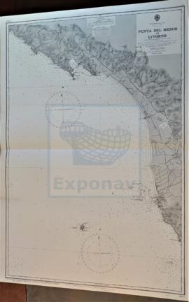
PUNTA DEL MESCO TO LIVORNO

  • ES EXPONAV CARTAS NÁUTICAS CCN-000220
  • Unidad documental simple
  • 1939
  • Parte deCARTAS NÁUTICAS

Zona Geográfica: Costa oeste de Italia. Mar Mediterráneo
Ciudades de Spezi y Livorno. Isla Gorgona

INSTITUTO HIDROGRÁFICO ITALIA

Resultados 91 a 100 de 118