- ES EXPONAV CARTAS NÁUTICAS CCN-000099
- Unidad documental simple
- 1943
Parte deCARTAS NÁUTICAS
Zona Geográfica: Costa Norte de Escocia
Aparecen las islas Orkney, Mainland y Sutherland
INSTITUTO HIDROGRÁFICO INGLATERRA
4 resultados directamente relacionados Excluir términos relacionados
Parte deCARTAS NÁUTICAS
Zona Geográfica: Costa Norte de Escocia
Aparecen las islas Orkney, Mainland y Sutherland
INSTITUTO HIDROGRÁFICO INGLATERRA
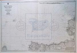
CAPE WRATH TO THE FLANNAN ISLES
Parte deCARTAS NÁUTICAS
Zona Geográfica: Costa norte de Escocia
Aparecen las tierras de Lewis y las tierras de Sutherland y Cromarty separadas por el North Minch
INSTITUTO HIDROGRÁFICO INGLATERRA
Parte deCARTAS NÁUTICAS
Zona Geográfica: Escocia. Islas Orcadas
Aparecen las islas Orcadas en la costa norte de Escocia.
INSTITUTO HIDROGRÁFICO INGLATERRA
ST. KILDA TO CAPE WRATH INCLUDING THE NORTH MINCH
Parte deCARTAS NÁUTICAS
Zona Geográfica: Costa Norte de Escocia
Aparece la isla de St. Kilda, la de isla de Lewis y North Minch.
INSTITUTO HIDROGRÁFICO INGLATERRA