CARTA NÁUTICA

Taxonomía

Código

Nota(s) sobre el alcance

Nota(s) sobre el origen

Mostrar nota(s)

Términos jerárquicos

CARTA NÁUTICA

Términos equivalentes

CARTA NÁUTICA

Términos asociados

CARTA NÁUTICA

324 Descripción archivística results for CARTA NÁUTICA

324 resultados directamente relacionados Excluir términos relacionados

CAPE THREE POINTS TO CAPE FORMOSO

  • ES EXPONAV CARTAS NÁUTICAS CCN-000046
  • Unidad documental simple
  • 1928
  • Parte deCARTAS NÁUTICAS

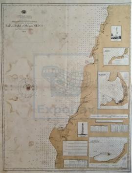
Zona Geográfica: Costa Occidental de África
Costa de África que va desde el cabo Tres Puntos hasta el Cabo Formoso. Zona de Nigeria. Ensenada de Benín, en el golfo de Guinea

INSTITUTO HIDROGRÁFICO INGLATERRA

CAPE VERDE TO CAPE ST. ANN

  • ES EXPONAV CARTAS NÁUTICAS CCN-000199
  • Unidad documental simple
  • 1939
  • Parte deCARTAS NÁUTICAS

Zona Geográfica: Costa oeste de África
Aparecen las tierras de Senegambia, Gambia, Guinea Portuguesa y Guinea Francesa

INSTITUTO HIDROGRÁFICO INGLATERRA

CAPE WRATH TO THE FLANNAN ISLES

  • ES EXPONAV CARTAS NÁUTICAS CCN-000177
  • Unidad documental simple
  • 1849
  • Parte deCARTAS NÁUTICAS

Zona Geográfica: Costa norte de Escocia
Aparecen las tierras de Lewis y las tierras de Sutherland y Cromarty separadas por el North Minch

INSTITUTO HIDROGRÁFICO INGLATERRA

CARNSORE POINT TO BRAICH-Y-PWLL

  • ES EXPONAV CARTAS NÁUTICAS CCN-000040
  • Unidad documental simple
  • 1954
  • Parte deCARTAS NÁUTICAS

Zona Geográfica: Canal de San Jorge
Plano del canal de San Jorge y la bahía de Cardigan con las ciudades de Pembrokeshire y Merionetshire.

INSTITUTO HIDROGRÁFICO INGLATERRA

CAYO BAHIA DE CÁDIZ TO CAYOS SANTA MARÍA

  • ES EXPONAV CARTAS NÁUTICAS CCN-000308
  • Unidad documental simple
  • 1926
  • Parte deCARTAS NÁUTICAS

Zona Geográfica: Costa norte de Cuba. Indias Occidentales
Aparece la costa norte de Cuba desde cayo Bahía de Cádiz a cayos Santa María. Puerto de Sagua la Grande, el canal de San Nicolás, Santaren.

INSTITUTO HIDROGRÁFICO ESTADOS UNIDOS DE AMÉRICA

CAYO FRANCES TO CAIBARIEN

  • ES EXPONAV CARTAS NÁUTICAS CCN-000304
  • Unidad documental simple
  • 1927
  • Parte deCARTAS NÁUTICAS

Zona Geográfica: Costa norte de Cuba. Indias Occidentales
Ciudad de Caibarien, cayos Virazon, cayo Fragoso, cayo Herradura y cayo Canuco

INSTITUTO HIDROGRÁFICO ESTADOS UNIDOS DE AMÉRICA

CAYO GRANDE PAREDON TO PUNTA MATERNILLOS

  • ES EXPONAV CARTAS NÁUTICAS CCN-000299
  • Unidad documental simple
  • 1929
  • Parte deCARTAS NÁUTICAS

Zona Geográfica: Costa norte de Cuba. Indias Occidentales
Aparece Great Bahama bank, el canal Old Bahama, la bahía Jiguey y los cayos Guajaba, Sabinal y Coco

INSTITUTO HIDROGRÁFICO ESTADOS UNIDOS DE AMÉRICA

CAYO MOA GRANDE TO CAPE MAYSI

  • ES EXPONAV CARTAS NÁUTICAS CCN-000265
  • Unidad documental simple
  • 1932
  • Parte deCARTAS NÁUTICAS

Zona Geográfica: Costa norte de Cuba. Indias Occidentales
Aparecen el cabo Maysi, great Inagua y Winward passage

INSTITUTO HIDROGRÁFICO ESTADOS UNIDOS DE AMÉRICA

CAYOS SANTA MARÍA TO CAYO PAREDON GRANDE

  • ES EXPONAV CARTAS NÁUTICAS CCN-000311
  • Unidad documental simple
  • 1927
  • Parte deCARTAS NÁUTICAS

Zona Geográfica: Costa norte de Cuba. Indias Occidentales
Aparece la isla Turiguano, cayo Coco y cayo Romano. Bahías de Buenavista y San Juan de los Remedios

INSTITUTO HIDROGRÁFICO ESTADOS UNIDOS DE AMÉRICA

Resultados 61 a 70 de 324