- ES EXPONAV CARTAS NÁUTICAS CCN-000004
- Item
- 1952
Part of CARTAS NÁUTICAS
Zona Geográfica: Guinea Portuguesa
Plano de la mitad de la Isla Caravela con la Bahía da Escaramuça y el canal de Caravela
INSTITUTO HIDROGRÁFICO PORTUGAL
1 results with digital objects Show results with digital objects
Part of CARTAS NÁUTICAS
Zona Geográfica: Guinea Portuguesa
Plano de la mitad de la Isla Caravela con la Bahía da Escaramuça y el canal de Caravela
INSTITUTO HIDROGRÁFICO PORTUGAL
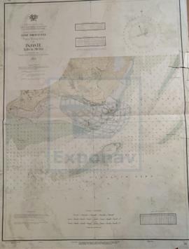
Part of CARTAS NÁUTICAS
Zona Geográfica: Ilha de Pecixe
Río Mansea, canal do Geba, islote de Ancora, isla dos Pássaros, isla de Cabaceira
INSTITUTO HIDROGRÁFICO PORTUGAL
PLANS IN THE ARQUIPÉLAGO DOS AÇORES
Part of CARTAS NÁUTICAS
Zona Geográfica: Mar Atlántico
Aparecen varios planos: Isla Terceira a escala 1:150000 (1951); bahía de Praia de Vitoria a 1:12000 (1947); porto de Angra a 1:18000 (1957-58); Folga a 1:12000 (1947-57); Santa Cruz a 1:12000 (1947); Vila de Praia a 1:12000 (1947-57); isla Graciosa a 1:150000 (1957)
INSTITUTO HIDROGRÁFICO PORTUGAL
Part of CARTAS NÁUTICAS
Zona Geográfica: Guinea portuguesa
Faro de Cacheu. Marca do baxo, marca Galicha y marca do Bxo. M. Amelia
INSTITUTO HIDROGRÁFICO PORTUGAL