- ES EXPONAV CARTAS NÁUTICAS CCN-000015
- Item
- 1953
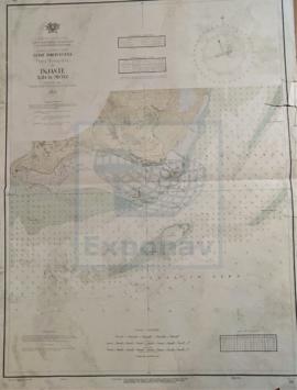
Part of CARTAS NÁUTICAS
Zona Geográfica: Guinea portuguesa
Faro de Cacheu. Marca do baxo, marca Galicha y marca do Bxo. M. Amelia
INSTITUTO HIDROGRÁFICO PORTUGAL
1 results with digital objects Show results with digital objects
Part of CARTAS NÁUTICAS
Zona Geográfica: Guinea portuguesa
Faro de Cacheu. Marca do baxo, marca Galicha y marca do Bxo. M. Amelia
INSTITUTO HIDROGRÁFICO PORTUGAL
PLANS IN THE ARQUIPÉLAGO DOS AÇORES
Part of CARTAS NÁUTICAS
Zona Geográfica: Mar Atlántico
Aparecen varios planos: Isla Terceira a escala 1:150000 (1951); bahía de Praia de Vitoria a 1:12000 (1947); porto de Angra a 1:18000 (1957-58); Folga a 1:12000 (1947-57); Santa Cruz a 1:12000 (1947); Vila de Praia a 1:12000 (1947-57); isla Graciosa a 1:150000 (1957)
INSTITUTO HIDROGRÁFICO PORTUGAL
Part of CARTAS NÁUTICAS
Zona Geográfica: Ilha de Pecixe
Río Mansea, canal do Geba, islote de Ancora, isla dos Pássaros, isla de Cabaceira
INSTITUTO HIDROGRÁFICO PORTUGAL
Part of CARTAS NÁUTICAS
Zona Geográfica: Guinea Portuguesa
Plano de la mitad de la Isla Caravela con la Bahía da Escaramuça y el canal de Caravela
INSTITUTO HIDROGRÁFICO PORTUGAL