PRAWLE POINT TO HENGISTBURY HEAD
- ES EXPONAV CARTAS NÁUTICAS CCN-000170
- Item
- 1957
Parte de CARTAS NÁUTICAS
Zona Geográfica: Costa sur de Inglaterra
Tierras de Devonshire, Dorsetchire, Hampshire y la bahía Lyme
INSTITUTO HIDROGRÁFICO INGLATERRA
18 resultados com objetos digitais Mostrar resultados com objetos digitais
PRAWLE POINT TO HENGISTBURY HEAD
Parte de CARTAS NÁUTICAS
Zona Geográfica: Costa sur de Inglaterra
Tierras de Devonshire, Dorsetchire, Hampshire y la bahía Lyme
INSTITUTO HIDROGRÁFICO INGLATERRA

PORT ROYAL AND KINGSTON HARBORS AND APPROACHES
Parte de CARTAS NÁUTICAS
Zona Geográfica: Costa sur de Jamaica. Indias Occidentales
Ciudad y puerto de Kingston. Incluye un recuadro con Ship Channel a escala 1:12500
INSTITUTO HIDROGRÁFICO INGLATERRA
PLANS ON THE SOUTH COAST OF WALES
Parte de CARTAS NÁUTICAS
Zona Geográfica: Islas Británicas
Aparece la bahía de Swansea y los alrededores de Porthcawl
INSTITUTO HIDROGRÁFICO INGLATERRA
Parte de CARTAS NÁUTICAS
Zona Geográfica: Mar del Norte
Dividido en dos recuadros que incluyen Zeegat van Texel a escala 1:50000 (1954) y Ijmuiden Habor a escala 1:12500 (1947)
INSTITUTO HIDROGRÁFICO PAÍSES BAJOS
Parte de CARTAS NÁUTICAS
Zona Geográfica: Océano Atlántico Norte
Plano de la bahía de las Palmas, bahía del Confital y entre medias la Isleta.
INSTITUTO HIDROGRÁFICO INGLATERRA
PLANO DEL ARCHIPIÉLAGO DE CABO VERDE
Parte de CARTAS NÁUTICAS
Zona Geográfica: Océano Atlántico Norte
Plano de las diferentes islas que forman el archipiélago de Cabo Verde.
Contiene recuadros con los puertos de Praia y Preguiça.
INSTITUTO HIDROGRÁFICO INGLATERRA
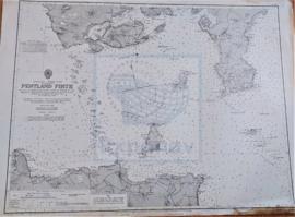
Parte de CARTAS NÁUTICAS
Zona Geográfica: Costa norte de Escocia
Tierras de la isla de Hoy, South Walls y South Ronaldsay. El estrecho de Outer y la isla de Stroma
INSTITUTO HIDROGRÁFICO INGLATERRA
OUTER GABBARD TO OUTER DOWSING
Parte de CARTAS NÁUTICAS
Zona Geográfica: Costa este de Inglaterra
Contiene las tierras de Norfolk, Suffolk y Essex
INSTITUTO HIDROGRÁFICO INGLATERRA
Parte de CARTAS NÁUTICAS
Zona Geográfica: Escocia. Islas Orcadas
Aparecen las islas Orcadas en la costa norte de Escocia.
INSTITUTO HIDROGRÁFICO INGLATERRA
ORFORDNESS & SCHEVENINGEN TO TERSCHELLING ZEEGAT
Parte de CARTAS NÁUTICAS
Zona Geográfica: Mar del Norte
Aparece a la izquierda Norfolk y Suffolk, a la derecha North Holland
INSTITUTO HIDROGRÁFICO INGLATERRA