- ES EXPONAV CARTAS NÁUTICAS CCN-000051
- Item
- 1937
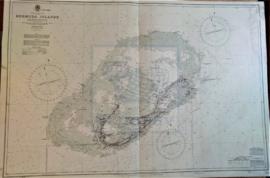
Part of CARTAS NÁUTICAS
Zona Geográfica: Océano Atlántico Norte
Plano de las islas Bermudas con sus principales puertos e islas.
INSTITUTO HIDROGRÁFICO INGLATERRA
1 results with digital objects Show results with digital objects
Part of CARTAS NÁUTICAS
Zona Geográfica: Océano Atlántico Norte
Plano de las islas Bermudas con sus principales puertos e islas.
INSTITUTO HIDROGRÁFICO INGLATERRA
PLANO DEL ARCHIPIÉLAGO DE CABO VERDE
Part of CARTAS NÁUTICAS
Zona Geográfica: Océano Atlántico Norte
Plano de las diferentes islas que forman el archipiélago de Cabo Verde.
Contiene recuadros con los puertos de Praia y Preguiça.
INSTITUTO HIDROGRÁFICO INGLATERRA
Part of CARTAS NÁUTICAS
Zona Geográfica: Atlántico norte
Aparece la costa de Noruega y las islas Feroe
INSTITUTO HIDROGRÁFICO INGLATERRA
Part of CARTAS NÁUTICAS
Zona Geográfica: Océano Atlántico Norte
Archipiélago de Cabo Verde, formado por las islas de Brava, Fuego, Santiago, Maio, Buena Vista, Sal, San Nicolás, Santa Lucía, San Vicente y San Antonio.
INSTITUTO HIDROGRÁFICO INGLATERRA