CHEVENINGEN TO AMELAND INCLUDING THE ZUIDER ZEE
- ES EXPONAV CARTAS NÁUTICAS CCN-000168
- Item
- 1923
Part of CARTAS NÁUTICAS
Zona Geográfica: Mar del Norte
Tierras de North Holland, Gelderland y Friesland
INSTITUTO HIDROGRÁFICO PAÍSES BAJOS
34 results with digital objects Show results with digital objects
CHEVENINGEN TO AMELAND INCLUDING THE ZUIDER ZEE
Part of CARTAS NÁUTICAS
Zona Geográfica: Mar del Norte
Tierras de North Holland, Gelderland y Friesland
INSTITUTO HIDROGRÁFICO PAÍSES BAJOS
Part of CARTAS NÁUTICAS
Zona Geográfica: Francia costa norte
Costa norte de Francia con los puertos de Cherburgo y Le Havre
INSTITUTO HIDROGRÁFICO FRANCIA
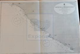
CESTOS BAY TO GRAND BUTU POINT
Part of CARTAS NÁUTICAS
Zona Geográfica: Costa Oeste de África. Liberia
Costa de África desde la bahía de Cestos hasta Gran Butu.
Aparecen los ríos Sangwin y Poa, montañas y ciudades de Liberia.
INSTITUTO HIDROGRÁFICO INGLATERRA
CEFALÚ TO MAZARA DEL VALLO INCLUDING THE ISLAND OF USTICA
Part of CARTAS NÁUTICAS
Zona Geográfica: Mar Mediterráneo. Sicilia
Zona mediterránea que va desde Cefalú hasta Mazarra del Vallo. Incluye la isla de Ustica y las islas Agadean
INSTITUTO HIDROGRÁFICO INGLATERRA
CAYOS SANTA MARÍA TO CAYO PAREDON GRANDE
Part of CARTAS NÁUTICAS
Zona Geográfica: Costa norte de Cuba. Indias Occidentales
Aparece la isla Turiguano, cayo Coco y cayo Romano. Bahías de Buenavista y San Juan de los Remedios
INSTITUTO HIDROGRÁFICO ESTADOS UNIDOS DE AMÉRICA
Part of CARTAS NÁUTICAS
Zona Geográfica: Costa norte de Cuba. Indias Occidentales
Aparecen el cabo Maysi, great Inagua y Winward passage
INSTITUTO HIDROGRÁFICO ESTADOS UNIDOS DE AMÉRICA
CAYO GRANDE PAREDON TO PUNTA MATERNILLOS
Part of CARTAS NÁUTICAS
Zona Geográfica: Costa norte de Cuba. Indias Occidentales
Aparece Great Bahama bank, el canal Old Bahama, la bahía Jiguey y los cayos Guajaba, Sabinal y Coco
INSTITUTO HIDROGRÁFICO ESTADOS UNIDOS DE AMÉRICA
Part of CARTAS NÁUTICAS
Zona Geográfica: Costa norte de Cuba. Indias Occidentales
Ciudad de Caibarien, cayos Virazon, cayo Fragoso, cayo Herradura y cayo Canuco
INSTITUTO HIDROGRÁFICO ESTADOS UNIDOS DE AMÉRICA
CAYO BAHIA DE CÁDIZ TO CAYOS SANTA MARÍA
Part of CARTAS NÁUTICAS
Zona Geográfica: Costa norte de Cuba. Indias Occidentales
Aparece la costa norte de Cuba desde cayo Bahía de Cádiz a cayos Santa María. Puerto de Sagua la Grande, el canal de San Nicolás, Santaren.
INSTITUTO HIDROGRÁFICO ESTADOS UNIDOS DE AMÉRICA
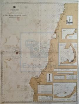
CARTA HIDROGRÁFICA DA COSTA DESDE A BAIA DO BABA Á COVA DOS MEDOS
Part of CARTAS NÁUTICAS
Zona Geográfica: África occidental portuguesa (Angola)
Bahía do Baba, puerto de Mossamedes y Alexandre
INSTITUTO HIDROGRÁFICO PORTUGAL