- ES EXPONAV CARTAS NÁUTICAS CCN-000090
- Stuk
- 1888
Part of CARTAS NÁUTICAS
Zona Geográfica: Costa sur de Irlanda
Zona del puerto de Cork y sus alrededores. Aparecen Great Island, Little Island y Foaty Island.
INSTITUTO HIDROGRÁFICO INGLATERRA
7 results with digital objects Show results with digital objects
Part of CARTAS NÁUTICAS
Zona Geográfica: Costa sur de Irlanda
Zona del puerto de Cork y sus alrededores. Aparecen Great Island, Little Island y Foaty Island.
INSTITUTO HIDROGRÁFICO INGLATERRA
DE L'ENTRÉE DE LA DIVES AU CAP D'ANTIFER EMBOUCHURE DE LA SEINE
Part of CARTAS NÁUTICAS
Zona Geográfica: Costa norte de Francia
Entrada de los puertos de Le Havre y Trouville y Drauville, en los departamentos de Seina Inferieure y Calvados
INSTITUTO HIDROGRÁFICO FRANCIA
DIE ELBE SCHARHÖRN RIFF TO BRUNSBÜTTELKOOG
Part of CARTAS NÁUTICAS
Zona Geográfica: Mar del Norte
Desembocadura del río Elba. Contiene recuadros de Brunsbüttelkoog a escala 1: 10000 y Cuxhaven Reede a escala 1: 12500
INSTITUTO HIDROGRÁFICO ALEMANIA
Part of CARTAS NÁUTICAS
Zona Geográfica: Florida. Estados Unidos de América
Aparece Loggerhead Key, Garden Key y East Key.
Contiene un recuadro con el Puerto de Tortugas a escala 1: 10000
INSTITUTO HIDROGRÁFICO ESTADOS UNIDOS DE AMÉRICA
ENTRANCE TO SIERRA LEONA RIVER
Part of CARTAS NÁUTICAS
Zona Geográfica: Costa Oeste de África
Costa de África, en concreto la entrada del río Sierra Leona con un plano de la ciudad de Freetown.
Aparecen la bahía de Cockerill, el río Bunceo y Bullom Shore.
INSTITUTO HIDROGRÁFICO INGLATERRA
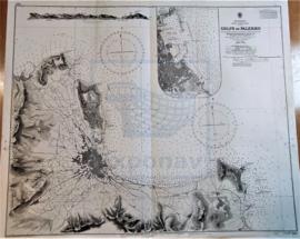
Part of CARTAS NÁUTICAS
Zona Geográfica: Mar Mediterráneo. Costa norte de Sicilia
Costa norte de la isla de Sicilia (Italia), concretamente del golfo de Palermo.
INSTITUTO HIDROGRÁFICO INGLATERRA
Part of CARTAS NÁUTICAS
Zona Geográfica: Indias Occidentales
Recuadro del puerto de Cristóbal Colón.
Recuadro de Bocas del Dragón, el Golfo de Paria, costa de Venezuela y las islas de Patos, Chacachacare, Huevos, Monos y Trinidad
INSTITUTO HIDROGRÁFICO INGLATERRA
GRAN BEREBI TO CAPE THREE POINTS
Part of CARTAS NÁUTICAS
Zona Geográfica: Costa oeste de África
Contiene dos recuadros: Gran Berebi to Jack Jack con Sassandra anchorage y Jack Jack to cape Three Points con port Bouet
INSTITUTO HIDROGRÁFICO INGLATERRA
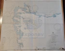
GUADELOUPE APPROACHES TO POINTE À PITRE
Part of CARTAS NÁUTICAS
Zona Geográfica: Guadalupe. Indias Occidentales
Aparece la ciudad de Pointre à Pitre y Petit Cul de Sac Marin
INSTITUTO HIDROGRÁFICO FRANCIA
GUADELOUPE APPROACHES TO POINTE À PITRE
Part of CARTAS NÁUTICAS
Zona Geográfica: Guadalupe. Indias Occidentales
Aparece la ciudad de Pointre à Pitre y Petit Cul de Sac Marin
INSTITUTO HIDROGRÁFICO FRANCIA