- ES EXPONAV CARTAS NÁUTICAS CCN-000191
- Item
- 1833
Part of CARTAS NÁUTICAS
Zona Geográfica: Islas británicas
Islas Shetland (Mainland, Yell y Unst)
INSTITUTO HIDROGRÁFICO INGLATERRA
34 results with digital objects Show results with digital objects
Part of CARTAS NÁUTICAS
Zona Geográfica: Islas británicas
Islas Shetland (Mainland, Yell y Unst)
INSTITUTO HIDROGRÁFICO INGLATERRA
Part of CARTAS NÁUTICAS
Zona Geográfica: Costa este de Inglaterra
Contiene las tierras de Yorkshire, Lincolnshire y Norfolk
INSTITUTO HIDROGRÁFICO INGLATERRA
GRAN BEREBI TO CAPE THREE POINTS
Part of CARTAS NÁUTICAS
Zona Geográfica: Costa oeste de África
Contiene dos recuadros: Gran Berebi to Jack Jack con Sassandra anchorage y Jack Jack to cape Three Points con port Bouet
INSTITUTO HIDROGRÁFICO INGLATERRA
Part of CARTAS NÁUTICAS
Zona Geográfica: Costa este de Inglaterra
Aparece la bahía de Tees y el puente Victoria a la misma escala
INSTITUTO HIDROGRÁFICO INGLATERRA
Part of CARTAS NÁUTICAS
Zona Geográfica: Mar Báltico
Aparece el mar Báltico con la isla Gotland en el centro. Costas de Polonia, Lituania, Letonia, Estonia y Suecia.
INSTITUTO HIDROGRÁFICO ALEMANIA
Part of CARTAS NÁUTICAS
Zona Geográfica: Mar Báltico
Aparecen las costas de Noruega, Suecia y Dinamarca. Las tierras de Jutlandia. Isla de Fyen
INSTITUTO HIDROFRÁFICO NORUEGA
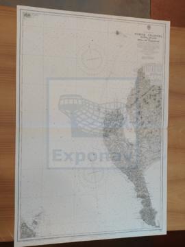
NORTH CHANNEL. SANDA ISLANS TO MULL OF GALLOWAY
Part of CARTAS NÁUTICAS
Zona Geográfica: Costa oeste de Escocia
Aparece el Canal del Norte, parte de la costa de Irlanda y Therinns en la isla Sanda
INSTITUTO HIDROGRÁFICO INGLATERRA
Part of CARTAS NÁUTICAS
Zona Geográfica: Atlántico norte
Aparece la costa de Noruega y las islas Feroe
INSTITUTO HIDROGRÁFICO INGLATERRA
Part of CARTAS NÁUTICAS
Zona Geográfica: Costa oeste de Inglaterra
Aparecen las tierras de Cumberland, Dumfries y Kirkcudbright.
INSTITUTO HIDROGRÁFICO INGLATERRA
EASTERN PART OF HAITI TO PUERTO RICO INCLUDING MONA PASSAGE
Part of CARTAS NÁUTICAS
Zona Geográfica: Indias Occidentales
Aparecen Haití, República Dominicana y la costa oeste de Puerto Rico
INSTITUTO HIDROGRÁFICO ESTADOS UNIDOS DE AMÉRICA