Showing 161 results

Archivistische beschrijving
INSTITUTO HIDROGRÁFICO INGLATERRA Spaans
Advanced search options
Print preview View:

18 results with digital objects Show results with digital objects

HORTA AND PIM BAYS / FAYAL CHANNEL

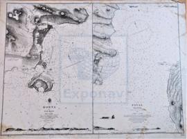
Zona Geográfica: Océano Atlántico. Azores
Carta dividida en dos: una parte es la bahía de Horta y costa de la isla Fayal; la otra parte es el canal de Fayal

INSTITUTO HIDROGRÁFICO INGLATERRA

ILES DE LOS TO SHERBRO ISLAND

Zona Geográfica: Costa oeste de África
Tierras de Guinea Francesa, Sierra Leona y la isla Sherbro

INSTITUTO HIDROGRÁFICO INGLATERRA

ISLAND OF ISLAY

Zona Geográfica: Costa oeste de Escocia
Aparecen las islas de Islay y Jura; bahía de Laggan

INSTITUTO HIDROGRÁFICO INGLATERRA

ISLAND OF LINNEY HEAD TO OXWICH POINT

Zona Geográfica: Costa sur de Gales
Aparecen las tierras de Pembrokeshire y Carmarthenshire. Bahía de Carmarthen

INSTITUTO HIDROGRÁFICO INGLATERRA

ISLANDS AND BANKS BETWEEN SAN SALVADOR AND SANTO DOMINGO

Zona Geográfica: Islas de las Indias Occidentales
Islas y bancos entre San Salvador y Santo Domingo: Turks islands, Great Inagua, Mayaguana, Acklins island.
Parte de las islas de Cuba y Haití.

INSTITUTO HIDROGRÁFICO INGLATERRA

ISLANDS IN THE SOUTHERN PORTION OF THE RED SEA

Zona Geográfica: Mar Rojo
Contiene 3 recuadros con: Zubair island a escala 1:96800; Zuqar island y Hanish islands a escala 1: 96600 y Abu'Ali Channel a escala 1:36950

INSTITUTO HIDROGRÁFICO INGLATERRA

ISLE OF MAN

Zona Geográfica: Mar de Irlanda
Aparece la isla de Man. Contiene recuadros con las bahías de Castletown y Ramsey, el puerto de St. Mary, Calf Sound, Port Erin y Peel.

INSTITUTO HIDROGRÁFICO INGLATERRA

ISOLE DAHLAC TO ZUQAR

Zona Geográfica: Mar Rojo
Aparecen tierras de Eritrea y Yemen. Islas Dahlac, Zubair y Zuqar

INSTITUTO HIDROGRÁFICO ITALIA

Resultaten 81 tot 90 van 161