- ES EXPONAV CARTAS NÁUTICAS CCN-000099
- Pièce
- 1943
Fait partie de CARTAS NÁUTICAS
Zona Geográfica: Costa Norte de Escocia
Aparecen las islas Orkney, Mainland y Sutherland
INSTITUTO HIDROGRÁFICO INGLATERRA
1 résultats avec objets numériques Afficher les résultats avec des objets numériques
Fait partie de CARTAS NÁUTICAS
Zona Geográfica: Costa Norte de Escocia
Aparecen las islas Orkney, Mainland y Sutherland
INSTITUTO HIDROGRÁFICO INGLATERRA
CAPE WRATH TO THE FLANNAN ISLES
Fait partie de CARTAS NÁUTICAS
Zona Geográfica: Costa norte de Escocia
Aparecen las tierras de Lewis y las tierras de Sutherland y Cromarty separadas por el North Minch
INSTITUTO HIDROGRÁFICO INGLATERRA
Fait partie de CARTAS NÁUTICAS
Zona Geográfica: Escocia. Islas Orcadas
Aparecen las islas Orcadas en la costa norte de Escocia.
INSTITUTO HIDROGRÁFICO INGLATERRA
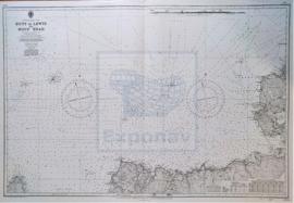
ST. KILDA TO CAPE WRATH INCLUDING THE NORTH MINCH
Fait partie de CARTAS NÁUTICAS
Zona Geográfica: Costa Norte de Escocia
Aparece la isla de St. Kilda, la de isla de Lewis y North Minch.
INSTITUTO HIDROGRÁFICO INGLATERRA