- ES EXPONAV CARTAS NÁUTICAS CCN-000251
- Stuk
- 1824
Part of CARTAS NÁUTICAS
Zona Geográfica: Indias Occidentales
Aparece la isla Martinica
INSTITUTO HIDROGRÁFICO FRANCIA
2 results with digital objects Show results with digital objects
Part of CARTAS NÁUTICAS
Zona Geográfica: Indias Occidentales
Aparece la isla Martinica
INSTITUTO HIDROGRÁFICO FRANCIA
Part of CARTAS NÁUTICAS
Zona Geográfica: África
Aparece la bahía y ciudad de Algeria y la región de Mitidja.
INSTITUTO HIDROGRÁFICO FRANCIA
Part of CARTAS NÁUTICAS
Zona Geográfica: Entre Argelia y Cherchel. Mar Mediterráneo
Aparece la llanura de Mitidja y las ciudades de Argel y Cherchel
INSTITUTO HIDROGRÁFICO FRANCIA
Part of CARTAS NÁUTICAS
Zona Geográfica: África costa norte
Aparecen las tierras de Beni Hidja, Beni Zioui, Beni Mnacer, Beni Zatyma, Beni Ali.
Incluye una vista de la costa
INSTITUTO HIDROGRÁFICO FRANCIA
GUADELOUPE APPROACHES TO POINTE À PITRE
Part of CARTAS NÁUTICAS
Zona Geográfica: Guadalupe. Indias Occidentales
Aparece la ciudad de Pointre à Pitre y Petit Cul de Sac Marin
INSTITUTO HIDROGRÁFICO FRANCIA
GUADELOUPE APPROACHES TO POINTE À PITRE
Part of CARTAS NÁUTICAS
Zona Geográfica: Guadalupe. Indias Occidentales
Aparece la ciudad de Pointre à Pitre y Petit Cul de Sac Marin
INSTITUTO HIDROGRÁFICO FRANCIA
CÔTE SEPTENTRIONALE D'AFRIQUE. PARTIE COMPRISE ENTRE DELLYS ET LE CAP SIGLI
Part of CARTAS NÁUTICAS
Zona Geográfica: norte de África
Costa septentrional de África con el puerto de Dellys y los cabos Bengut, Tedles, Corbelin y Sigli
INSTITUTO HIDROGRÁFICO FRANCIA
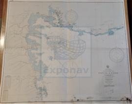
COURS DE L'ADOUR DEPUIS SON EMBOUCHURE JUSQU' À BAYONNE
Part of CARTAS NÁUTICAS
Zona Geográfica: Costa oeste de Francia
Canal de entrada a Bayona con el parcelario de la bahía de San Juan de Luz
INSTITUTO HIDROGRÁFICO FRANCIA
Part of CARTAS NÁUTICAS
Zona Geográfica: Egipto. Mar Mediterráneo
Costa de Egipto desde Port Said hasta Alejandría con la bahía de Aboukir, las entradas de Rosette y Damiette
INSTITUTO HIDROGRÁFICO FRANCIA
Part of CARTAS NÁUTICAS
Zona Geográfica: Costa de Argelia. Mar Mediterráneo
Portulano del puerto de Argel.
Incluye un recuadro de Mouillage de la Pointe Pescade
INSTITUTO HIDROGRÁFICO FRANCIA