- ES EXPONAV CARTAS NÁUTICAS CCN-000319
- Item
- 1867
Part of CARTAS NÁUTICAS
Zona Geográfica: Entre Argelia y Cherchel. Mar Mediterráneo
Aparece la llanura de Mitidja y las ciudades de Argel y Cherchel
INSTITUTO HIDROGRÁFICO FRANCIA
1 results with digital objects Show results with digital objects
Part of CARTAS NÁUTICAS
Zona Geográfica: Entre Argelia y Cherchel. Mar Mediterráneo
Aparece la llanura de Mitidja y las ciudades de Argel y Cherchel
INSTITUTO HIDROGRÁFICO FRANCIA
DU CAP FERRAT À LA POINTE KEF EL ASFER
Part of CARTAS NÁUTICAS
Zona Geográfica: Costa de Argelia. Mar Mediterráneo
Golfo de d'Arzeu, ciudad de Arzeu, Mostaganem.
INSTITUTO HIDROGRÁFICO FRANCIA
Part of CARTAS NÁUTICAS
Zona Geográfica: Mar Mediterráneo. Costa norte de Túnez
Aparece la costa tunecina con los lagos de Lishkoel, Bizerte y Porto Farina y el golfo de Túnez.
INSTITUTO HIDROGRÁFICO FRANCIA
Part of CARTAS NÁUTICAS
Zona Geográfica: Costa sur de Francia. Mar Mediterráneo
Aparece la ciudad de Marsella y el golfo de Fos.
Incluye un recuadro con el puerto de Bouc a escala 1:29160
INSTITUTO HIDROGRÁFICO FRANCIA
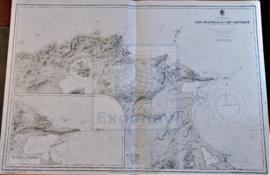
Part of CARTAS NÁUTICAS
Zona Geográfica: África del norte. Mar Mediterráneo
Desde la punta Kef el Assfer al cabo Tenes.
Incluye una vista de la costa
INSTITUTO HIDROGRÁFICO FRANCIA