- ES EXPONAV CARTAS NÁUTICAS CCN-000078
- Stuk
- 1956
Part of CARTAS NÁUTICAS
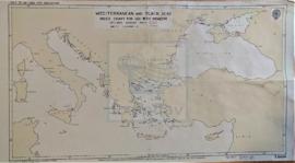
Zona Geográfica: Mar Mediterráneo
Visión del Mar Mediterráneo en la que están marcadas las zonas peligrosas y el Mar Negro.
INSTITUTO HIDROGRÁFICO INGLATERRA
34 results with digital objects Show results with digital objects
Part of CARTAS NÁUTICAS
Zona Geográfica: Mar Mediterráneo
Visión del Mar Mediterráneo en la que están marcadas las zonas peligrosas y el Mar Negro.
INSTITUTO HIDROGRÁFICO INGLATERRA
Part of CARTAS NÁUTICAS
Zona Geográfica: Mar Mediterráneo
Carta completa del Mar Mediterráneo y del Mar Negro en la que aparecen todos los países cuyas costas son bañadas por estos mares.
INSTITUTO HIDROGRÁFICO INGLATERRA
MECKLENBURGER BUCHT TO GREIFSWALDER BODDEN
Part of CARTAS NÁUTICAS
Zona Geográfica: Mar Báltico
Tierras de Pommern y Rügen. Contiene un recuadro con Warnemünde Hafen a escala 1:25000
INSTITUTO HIDROGRÁFICO DINAMARCA
Part of CARTAS NÁUTICAS
Zona Geográfica: Sicilia. Mar Mediterráneo
Costa suroeste de Sicilia con la isla de Pantellería
INSTITUTO HIDROGRÁFICO INGLATERRA
MATANZAS TO CAYO BAHIA DE CÁDIZ
Part of CARTAS NÁUTICAS
Zona Geográfica: Costa norte de Cuba. Indias Occidentales
Aparecen las bahías de Cardenas, Santa Clara, Carahatas y Matanzas, la ciudad de Matanzas, el canal de San Nicolás y cayo Sal.
INSTITUTO HIDROGRÁFICO ESTADOS UNIDOS DE AMÉRICA
MASAMIRIT ISLAND TO ZUBAIR ISLAND
Part of CARTAS NÁUTICAS
Zona Geográfica: Mar Rojo
Aparecen tierras de Hejaz, Eritrea, Yemen y Asir.
Incluye dos recuadros con Gubbet Muse Nefit a escala 1:120000 y Nocra anchorage and channel a escala 1:30000
INSTITUTO HIDROGRÁFICO ITALIA
Part of CARTAS NÁUTICAS
Zona Geográfica: Costa Oeste de África
Costa de África que va desde Luanda hasta la bahía dos Tigres.
Aparece la península de los Tigres, el río Cuanza y los cabos de Tres Puntas y el de Santa Marta, entre otros.
INSTITUTO HIDROGRÁFICO INGLATERRA
LOFOTEN ISLANDS TO VEST SPITSBERGEN
Part of CARTAS NÁUTICAS
Zona Geográfica: Océano Ártico
Aparecen los mares de Greenland y Barents
Contiene un recuadro con Björnöya
INSTITUTO HIDROFRÁFICO NORUEGA
LOCHS ERISORT, LEURBOST AND GRIMSHADER
Part of CARTAS NÁUTICAS
Zona Geográfica: Costa oeste de Escocia
Contiene un recuadro con el lago Erisort y las entradas a Leurbost y Erisort
INSTITUTO HIDROGRÁFICO INGLATERRA
Part of CARTAS NÁUTICAS
Zona Geográfica: Sureste de Escocia. Islas Hébridas
Aparecen las islas de Ornish y Shillay More.
INSTITUTO HIDROGRÁFICO INGLATERRA