- ES EXPONAV CARTAS NÁUTICAS CCN-000071
- Item
- 1944
Part of CARTAS NÁUTICAS
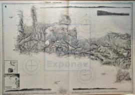
Zona Geográfica: Océano Atlántico
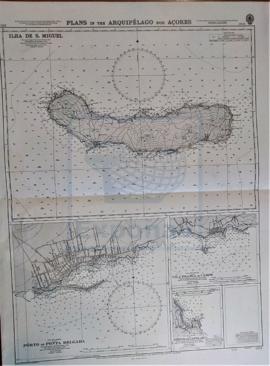
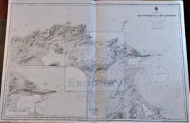
Recuadro con la isla de San Miguel
INSTITUTO HIDROGRÁFICO INGLATERRA
Part of CARTAS NÁUTICAS
Zona Geográfica: Océano Atlántico
Recuadro con la isla de San Miguel
INSTITUTO HIDROGRÁFICO INGLATERRA
Part of CARTAS NÁUTICAS
Zona Geográfica: Mar Mediterráneo
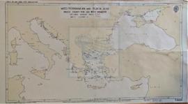
Visión del Mar Mediterráneo en la que están marcadas las zonas peligrosas y el Mar Negro.
INSTITUTO HIDROGRÁFICO INGLATERRA
Part of CARTAS NÁUTICAS
Zona Geográfica: Mar Báltico
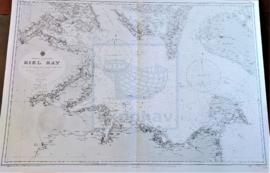
Aparecen la bahía de Kiel y las tierras de Lolland, Holstein y la isla Fehmarn
INSTITUTO HIDROGRÁFICO ALEMANIA
Part of CARTAS NÁUTICAS
Zona Geográfica: Mediterráneo
Isla de Creta. Contiene recuadros con Port Matala (escala 1: 9100), Sphakia (escala 1: 14560) y Anchorage
INSTITUTO HIDROGRÁFICO INGLATERRA
Part of CARTAS NÁUTICAS
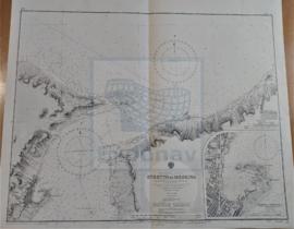
Zona Geográfica: Italia. Mar Mediterráneo
Parte norte del estrecho de Mesina con las costas de Sicilia y Calabria. Aparecen los puertos de Mesina y Scilla
INSTITUTO HIDROGRÁFICO ITALIA
Part of CARTAS NÁUTICAS
Zona Geográfica: Costa sur de Irlanda
Aparece Great Island, Spike island y Haulbowline island
INSTITUTO HIDROGRÁFICO INGLATERRA
Part of CARTAS NÁUTICAS
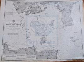
Zona Geográfica: Costa norte de Escocia
Tierras de la isla de Hoy, South Walls y South Ronaldsay. El estrecho de Outer y la isla de Stroma
INSTITUTO HIDROGRÁFICO INGLATERRA
Part of CARTAS NÁUTICAS
Zona Geográfica: Mar Mediterráneo. Costa norte de Túnez
Aparece la costa tunecina con los lagos de Lishkoel, Bizerte y Porto Farina y el golfo de Túnez.
INSTITUTO HIDROGRÁFICO FRANCIA
Part of CARTAS NÁUTICAS
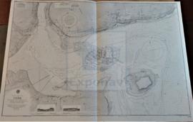
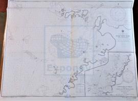
Zona Geográfica: Costa sur de Cuba. Indias Occidentales
Aparece la bahía de Niquero. Contiene un recuadro con las cercanías a Beliz incluyendo la bahía Guanito y el río Limones a escala 1:24321
INSTITUTO HIDROGRÁFICO ESTADOS UNIDOS DE AMÉRICA