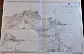
CHEVENINGEN TO AMELAND INCLUDING THE ZUIDER ZEE
- ES EXPONAV CARTAS NÁUTICAS CCN-000168
- Item
- 1923
Part of CARTAS NÁUTICAS
Zona Geográfica: Mar del Norte
Tierras de North Holland, Gelderland y Friesland
INSTITUTO HIDROGRÁFICO PAÍSES BAJOS
9 results with digital objects Show results with digital objects
CHEVENINGEN TO AMELAND INCLUDING THE ZUIDER ZEE
Part of CARTAS NÁUTICAS
Zona Geográfica: Mar del Norte
Tierras de North Holland, Gelderland y Friesland
INSTITUTO HIDROGRÁFICO PAÍSES BAJOS
Part of CARTAS NÁUTICAS
Zona Geográfica: Alemania
La carta se divide en tres sectores A, B y C con recuadros de Schirnauer a escala 1: 25000; Brunsbüttelkoog a escala 1: 10000 y Holtenau a escala 1: 10000
INSTITUTO HIDROGRÁFICO ALEMANIA
Part of CARTAS NÁUTICAS
Zona Geográfica: Mar Mediterráneo. Costa norte de Túnez
Aparece la costa tunecina con los lagos de Lishkoel, Bizerte y Porto Farina y el golfo de Túnez.
INSTITUTO HIDROGRÁFICO FRANCIA
SUSA TO MAHEDIA WITH THE KURIAT ISLANDS
Part of CARTAS NÁUTICAS
Zona Geográfica: Mar Mediterráneo. Túnez
Aparece el golfo de Monastir y las islas Kuriat.
Contiene una recuadro con el fondeadero de Monastir a escala 1:40400 y otro recuadro con el fondeadero de Mahedia a escala 1:40400
INSTITUTO HIDROGRÁFICO INGLATERRA
TREVOSE HEAD TO DODMAN POINT INCLUDING THE SCILLY ISLES
Part of CARTAS NÁUTICAS
Zona Geográfica: Costa suroeste de Inglaterra
Aparecen las tierras de Cornwall y las islas Scilly
INSTITUTO HIDROGRÁFICO INGLATERRA
Part of CARTAS NÁUTICAS
Zona Geográfica: Costa oeste de Inglaterra
Aparecen las tierras de Cumberland, Dumfries y Kirkcudbright.
INSTITUTO HIDROGRÁFICO INGLATERRA
Part of CARTAS NÁUTICAS
Zona Geográfica: Costa oeste de Francia
Aparecen las tierras de Charente Inferieur y Gironde, separadas por el río Gironde
INSTITUTO HIDROGRÁFICO FRANCIA
Part of CARTAS NÁUTICAS
Zona Geográfica: Mar del Norte. Islas Frisias
Aparece la costa norte de Alemania, Holanda y Friesland
INSTITUTO HIDROGRÁFICO ALEMANIA
Part of CARTAS NÁUTICAS
Zona Geográfica: Costa oeste de Italia. Mar Mediterráneo
Aparece la isla de Giglio, promontorio Argentario, ciudad de Civitavecchia y Fiumicino
INSTITUTO HIDROGRÁFICO ITALIA
Part of CARTAS NÁUTICAS
Zona Geográfica: Costa sur de Francia. Mar Mediterráneo
Aparece la ciudad de Marsella y el golfo de Fos.
Incluye un recuadro con el puerto de Bouc a escala 1:29160
INSTITUTO HIDROGRÁFICO FRANCIA