- ES EXPONAV CARTAS NÁUTICAS CCN-000071
- Item
- 1944
Part of CARTAS NÁUTICAS
Zona Geográfica: Océano Atlántico
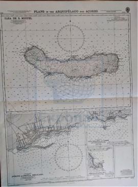
Recuadro con la isla de San Miguel
INSTITUTO HIDROGRÁFICO INGLATERRA
Part of CARTAS NÁUTICAS
Zona Geográfica: Océano Atlántico
Recuadro con la isla de San Miguel
INSTITUTO HIDROGRÁFICO INGLATERRA
Part of CARTAS NÁUTICAS
Zona Geográfica: Mar Báltico
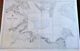
Aparecen la bahía de Kiel y las tierras de Lolland, Holstein y la isla Fehmarn
INSTITUTO HIDROGRÁFICO ALEMANIA
Part of CARTAS NÁUTICAS
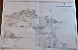
Zona Geográfica: Mar Mediterráneo. Costa norte de Túnez
Aparece la costa tunecina con los lagos de Lishkoel, Bizerte y Porto Farina y el golfo de Túnez.
INSTITUTO HIDROGRÁFICO FRANCIA
Part of CARTAS NÁUTICAS
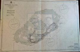
Zona Geográfica: Océano Atlántico Norte
Plano de las islas Bermudas con sus principales puertos e islas.
INSTITUTO HIDROGRÁFICO INGLATERRA
Part of CARTAS NÁUTICAS
Zona Geográfica: Costa Norte de Escocia
Aparecen las islas Orkney, Mainland y Sutherland
INSTITUTO HIDROGRÁFICO INGLATERRA

Part of CARTAS NÁUTICAS
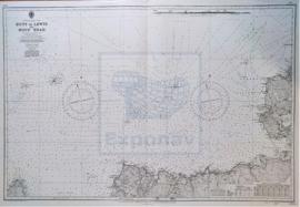
Zona Geográfica: Inglaterra costa oeste
Proximidades del puerto de Liverpool desde la punta de Great Ormes a Southport con las entradas de los ríos Dee y Mersey y los puertos de Liverpool y Birkenhead
INSTITUTO HIDROGRÁFICO INGLATERRA
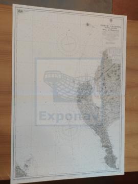
NORTH CHANNEL. SANDA ISLANS TO MULL OF GALLOWAY
Part of CARTAS NÁUTICAS
Zona Geográfica: Costa oeste de Escocia
Aparece el Canal del Norte, parte de la costa de Irlanda y Therinns en la isla Sanda
INSTITUTO HIDROGRÁFICO INGLATERRA
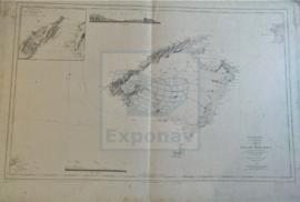
Part of CARTAS NÁUTICAS
Zona Geográfica: Baleares. Mar Mediterráneo
Primer plano de la isla de Mallorca; aparecen también las islas de Menorca y Cabrera.
Vista de la isla desde dos puntos diferentes.
Recuadro con la isla de Dragonera y un trozo de Mallorca.
INSTITUTO HIDROGRÁFICO ESPAÑA
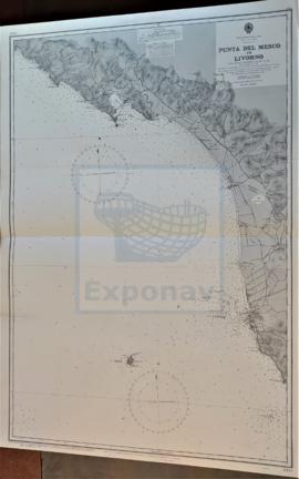
Part of CARTAS NÁUTICAS
Zona Geográfica: Costa oeste de Italia. Mar Mediterráneo
Ciudades de Spezi y Livorno. Isla Gorgona
INSTITUTO HIDROGRÁFICO ITALIA