- ES EXPONAV CARTAS NÁUTICAS CCN-000319
- Item
- 1867
Part of CARTAS NÁUTICAS
Zona Geográfica: Entre Argelia y Cherchel. Mar Mediterráneo
Aparece la llanura de Mitidja y las ciudades de Argel y Cherchel
INSTITUTO HIDROGRÁFICO FRANCIA
9 results with digital objects Show results with digital objects
Part of CARTAS NÁUTICAS
Zona Geográfica: Entre Argelia y Cherchel. Mar Mediterráneo
Aparece la llanura de Mitidja y las ciudades de Argel y Cherchel
INSTITUTO HIDROGRÁFICO FRANCIA
Part of CARTAS NÁUTICAS
Zona Geográfica: África costa norte
Aparecen las tierras de Beni Hidja, Beni Zioui, Beni Mnacer, Beni Zatyma, Beni Ali.
Incluye una vista de la costa
INSTITUTO HIDROGRÁFICO FRANCIA
Part of CARTAS NÁUTICAS
Zona Geográfica: Mar Rojo
Golfo de Suez
INSTITUTO HIDROGRÁFICO INGLATERRA
Part of CARTAS NÁUTICAS
Zona Geográfica: Costa oeste de Inglaterra
Aparecen las tierras de Cumberland, Dumfries y Kirkcudbright.
INSTITUTO HIDROGRÁFICO INGLATERRA
Part of CARTAS NÁUTICAS
Zona Geográfica: Costa oeste de Inglaterra
Aparecen las tierras de Cumberland, Dumfries y Kirkcudbright.
INSTITUTO HIDROGRÁFICO INGLATERRA
ISLANDS IN THE SOUTHERN PORTION OF THE RED SEA
Part of CARTAS NÁUTICAS
Zona Geográfica: Mar Rojo
Contiene 3 recuadros con: Zubair island a escala 1:96800; Zuqar island y Hanish islands a escala 1: 96600 y Abu'Ali Channel a escala 1:36950
INSTITUTO HIDROGRÁFICO INGLATERRA
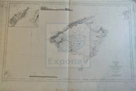
Part of CARTAS NÁUTICAS
Zona Geográfica: Baleares. Mar Mediterráneo
Primer plano de la isla de Mallorca; aparecen también las islas de Menorca y Cabrera.
Vista de la isla desde dos puntos diferentes.
Recuadro con la isla de Dragonera y un trozo de Mallorca.
INSTITUTO HIDROGRÁFICO ESPAÑA
HARBOURS AND ANCHORAGES ON THE COAST OF HAITI AND THE DOMINICAN REPUBLIC
Part of CARTAS NÁUTICAS
Zona Geográfica: Mar Caribe
Contiene 11 recuadros con St. Nicolás Mole a 1:25000; Cayemites Bay a 1:147410; Navassa Island a 1:23280; Acul Bay a 1:53000; Romana River entrance a 1:12500; Gran Pierre Bay a 1:50000; Port Jackson a 1:25180; St. Marc Bay a 1:36640; Jacmel Bay a 1:29150; Port Plata a 1:10100 y Puerto de la ciudad de Trujillo a 1:13130
INSTITUTO HIDROGRÁFICO ESTADOS UNIDOS DE AMÉRICA
PUERTO GIBARA TO CAYO MOA GRANDE
Part of CARTAS NÁUTICAS
Zona Geográfica: Costa norte de Cuba. Indias Occidentales
Aparecen las bahías Nipe y Banes, el puerto Gibara y cayo Moa Grande
INSTITUTO HIDROGRÁFICO ESTADOS UNIDOS DE AMÉRICA
Part of CARTAS NÁUTICAS
Zona Geográfica: Costa sur de Cuba. Indias Occidentales
Aparece el cabo Cruz, Sierra Maestra y la ensenada de Mora
INSTITUTO HIDROGRÁFICO ESTADOS UNIDOS DE AMÉRICA