- ES EXPONAV CARTAS NÁUTICAS CCN-000049
- Item
- 1873
Part of CARTAS NÁUTICAS
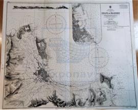
Zona Geográfica: Mar Mediterráneo. Costa norte de Sicilia
Costa norte de la isla de Sicilia (Italia), concretamente del golfo de Palermo.
INSTITUTO HIDROGRÁFICO INGLATERRA
7 results with digital objects Show results with digital objects
Part of CARTAS NÁUTICAS
Zona Geográfica: Mar Mediterráneo. Costa norte de Sicilia
Costa norte de la isla de Sicilia (Italia), concretamente del golfo de Palermo.
INSTITUTO HIDROGRÁFICO INGLATERRA
WEST SCHELDE OSTEND TO WESTKAPELLE
Part of CARTAS NÁUTICAS
Zona Geográfica: Mar del Norte
Schelde occidental desde Ostende hasta Westkapelle
INSTITUTO HIDROGRÁFICO INGLATERRA
BARRY & WATCHET TO NEWPORT & WESTON-SUPER-MARE
Part of CARTAS NÁUTICAS
Zona Geográfica: Costa oeste de Inglaterra. Canal de Bristol
Aparecen las ciudades de Newport, Penarth, Cardiff y Weston-super-mare. Las bahías de Bridgwater y de Cueston.
INSTITUTO HIDROGRÁFICO INGLATERRA
PORTS AND ANCHORAGES IN YUGOSLAVIA
Part of CARTAS NÁUTICAS
Zona Geográfica: Mar Mediterráneo. Mar Adriático
Carta dividida en 10 recuadros: Luka Ploce a 1:12000; Luka Polace a 1:24000; Zaliv Klek Neum a 1:36000; Usce Neretve a 1:36000; Luka Pomina a 1:36000; Kanal Malog Stona a 1:36000; Luka Zaton a 1:24000; Luka Slano a 1:24000; Luka Gruz a 1:24000 y Dubrovnick a 1:36000.
INSTITUTO HIDROGRÁFICO YUGOSLAVIA
DIE ELBE SCHARHÖRN RIFF TO BRUNSBÜTTELKOOG
Part of CARTAS NÁUTICAS
Zona Geográfica: Mar del Norte
Desembocadura del río Elba. Contiene recuadros de Brunsbüttelkoog a escala 1: 10000 y Cuxhaven Reede a escala 1: 12500
INSTITUTO HIDROGRÁFICO ALEMANIA
WESTERN APPROACHES TO PENTLAND FIRTH
Part of CARTAS NÁUTICAS
Zona Geográfica: Costa norte de Escocia
Aparecen Pentland firth, Mainland y la isla Hoy.
Contiene pequeños planos mostrando las corrientes marinas
INSTITUTO HIDROGRÁFICO INGLATERRA
ISLANDS IN THE SOUTHERN PORTION OF THE RED SEA
Part of CARTAS NÁUTICAS
Zona Geográfica: Mar Rojo
Contiene 3 recuadros con: Zubair island a escala 1:96800; Zuqar island y Hanish islands a escala 1: 96600 y Abu'Ali Channel a escala 1:36950
INSTITUTO HIDROGRÁFICO INGLATERRA
Part of CARTAS NÁUTICAS
Zona Geográfica: Mar del Norte
Dividido en dos recuadros que incluyen Zeegat van Texel a escala 1:50000 (1954) y Ijmuiden Habor a escala 1:12500 (1947)
INSTITUTO HIDROGRÁFICO PAÍSES BAJOS
HARBOURS AND ANCHORAGES ON THE COAST OF HAITI AND THE DOMINICAN REPUBLIC
Part of CARTAS NÁUTICAS
Zona Geográfica: Mar Caribe
Contiene 11 recuadros con St. Nicolás Mole a 1:25000; Cayemites Bay a 1:147410; Navassa Island a 1:23280; Acul Bay a 1:53000; Romana River entrance a 1:12500; Gran Pierre Bay a 1:50000; Port Jackson a 1:25180; St. Marc Bay a 1:36640; Jacmel Bay a 1:29150; Port Plata a 1:10100 y Puerto de la ciudad de Trujillo a 1:13130
INSTITUTO HIDROGRÁFICO ESTADOS UNIDOS DE AMÉRICA
Part of CARTAS NÁUTICAS
Zona Geográfica: Costa este de Irlanda
Aparece el condado de Down y el de Antrim. La isla de Copeland
Incluye un recuadro de los muelles de Belfast a escala 1:18000
INSTITUTO HIDROGRÁFICO INGLATERRA