- ES EXPONAV CARTAS NÁUTICAS CCN-000114
- Item
- 1871
Part of CARTAS NÁUTICAS
Zona Geográfica: Costa Oeste de Inglaterra
Aparecen las ciudades de Morecambe, Lancaster, Fleetwood y Barrow
INSTITUTO HIDROGRÁFICO INGLATERRA
7 results with digital objects Show results with digital objects
Part of CARTAS NÁUTICAS
Zona Geográfica: Costa Oeste de Inglaterra
Aparecen las ciudades de Morecambe, Lancaster, Fleetwood y Barrow
INSTITUTO HIDROGRÁFICO INGLATERRA
ISLANDS IN THE SOUTHERN PORTION OF THE RED SEA
Part of CARTAS NÁUTICAS
Zona Geográfica: Mar Rojo
Contiene 3 recuadros con: Zubair island a escala 1:96800; Zuqar island y Hanish islands a escala 1: 96600 y Abu'Ali Channel a escala 1:36950
INSTITUTO HIDROGRÁFICO INGLATERRA
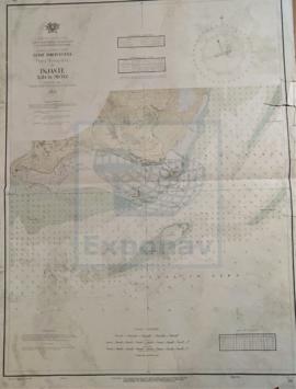
Part of CARTAS NÁUTICAS
Zona Geográfica: Indias Occidentales
Aparece la isla Martinica
INSTITUTO HIDROGRÁFICO FRANCIA
ISLAND OF ARRAN TO GARE LOCH INCLUDING THE FIRTH OF CLYDE, THE KYLES OF BUTE AND INCHMARNOCK WATER
Part of CARTAS NÁUTICAS
Zona Geográfica: Costa oeste de Escocia
Aparece la isla de Bute, las tierras de Argyllshire, Ammberton Shire y Firth of Clyde. Península de Kintyre
INSTITUTO HIDROGRÁFICO INGLATERRA
Part of CARTAS NÁUTICAS
Zona Geográfica: Ilha de Pecixe
Río Mansea, canal do Geba, islote de Ancora, isla dos Pássaros, isla de Cabaceira
INSTITUTO HIDROGRÁFICO PORTUGAL
HARBOURS AND ANCHORAGES ON THE COAST OF HAITI AND THE DOMINICAN REPUBLIC
Part of CARTAS NÁUTICAS
Zona Geográfica: Mar Caribe
Contiene 11 recuadros con St. Nicolás Mole a 1:25000; Cayemites Bay a 1:147410; Navassa Island a 1:23280; Acul Bay a 1:53000; Romana River entrance a 1:12500; Gran Pierre Bay a 1:50000; Port Jackson a 1:25180; St. Marc Bay a 1:36640; Jacmel Bay a 1:29150; Port Plata a 1:10100 y Puerto de la ciudad de Trujillo a 1:13130
INSTITUTO HIDROGRÁFICO ESTADOS UNIDOS DE AMÉRICA
GUADELOUPE APPROACHES TO POINTE À PITRE
Part of CARTAS NÁUTICAS
Zona Geográfica: Guadalupe. Indias Occidentales
Aparece la ciudad de Pointre à Pitre y Petit Cul de Sac Marin
INSTITUTO HIDROGRÁFICO FRANCIA
GUADELOUPE APPROACHES TO POINTE À PITRE
Part of CARTAS NÁUTICAS
Zona Geográfica: Guadalupe. Indias Occidentales
Aparece la ciudad de Pointre à Pitre y Petit Cul de Sac Marin
INSTITUTO HIDROGRÁFICO FRANCIA
GRAN BEREBI TO CAPE THREE POINTS
Part of CARTAS NÁUTICAS
Zona Geográfica: Costa oeste de África
Contiene dos recuadros: Gran Berebi to Jack Jack con Sassandra anchorage y Jack Jack to cape Three Points con port Bouet
INSTITUTO HIDROGRÁFICO INGLATERRA
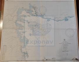
Part of CARTAS NÁUTICAS
Zona Geográfica: Indias Occidentales
Recuadro del puerto de Cristóbal Colón.
Recuadro de Bocas del Dragón, el Golfo de Paria, costa de Venezuela y las islas de Patos, Chacachacare, Huevos, Monos y Trinidad
INSTITUTO HIDROGRÁFICO INGLATERRA