GREAT BAHAMA BANK. NORTHEASTERN PART
- ES EXPONAV CARTAS NÁUTICAS CCN-000259
- Item
- 1836
Part of CARTAS NÁUTICAS
Zona Geográfica: Indias Occidentales
Islas de New Providence, Andros y Eleuthera
INSTITUTO HIDROGRÁFICO INGLATERRA
4 results with digital objects Show results with digital objects
GREAT BAHAMA BANK. NORTHEASTERN PART
Part of CARTAS NÁUTICAS
Zona Geográfica: Indias Occidentales
Islas de New Providence, Andros y Eleuthera
INSTITUTO HIDROGRÁFICO INGLATERRA
MASAMIRIT ISLAND TO ZUBAIR ISLAND
Part of CARTAS NÁUTICAS
Zona Geográfica: Mar Rojo
Aparecen tierras de Hejaz, Eritrea, Yemen y Asir.
Incluye dos recuadros con Gubbet Muse Nefit a escala 1:120000 y Nocra anchorage and channel a escala 1:30000
INSTITUTO HIDROGRÁFICO ITALIA
YUCATAN CHANNEL AND APPROACHES
Part of CARTAS NÁUTICAS
Zona Geográfica: Norte América
Aparece la isla de Cuba, Honduras y la costa este de México
INSTITUTO HIDROGRÁFICO ESTADOS UNIDOS DE AMÉRICA
BAFFU BAY TO GRAND BEREBI INCLUDING CAPE PALMAS
Part of CARTAS NÁUTICAS
Zona Geográfica: Costa oeste de África
Tierras de Liberia y costa de Ivory
INSTITUTO HIDROGRÁFICO INGLATERRA
OUTER GABBARD TO OUTER DOWSING
Part of CARTAS NÁUTICAS
Zona Geográfica: Costa este de Inglaterra
Contiene las tierras de Norfolk, Suffolk y Essex
INSTITUTO HIDROGRÁFICO INGLATERRA
Part of CARTAS NÁUTICAS
Zona Geográfica: Centro América
Aparecen Yucatán, Campeche, Tabasco, Vera Cruz, Tamulipas, Florida, Luisiana, Mississippi, Texas y la isla de Cuba
INSTITUTO HIDROGRÁFICO INGLATERRA
Part of CARTAS NÁUTICAS
Zona Geográfica: Costa oeste de África
Tierras de Guinea Francesa, Sierra Leona y la isla Sherbro
INSTITUTO HIDROGRÁFICO INGLATERRA
Part of CARTAS NÁUTICAS
Zona Geográfica: Canal de la Mancha
Canal de la Mancha separando el sur de Inglaterra de Francia, Aparece la costa de Inglaterra de Plymouth a Portshire
INSTITUTO HIDROGRÁFICO INGLATERRA
RIVER BENIN TO RIVER CAMEROONS INCLUDING THE MOUTHS OF THE RIVER KWARA OR NIGER
Part of CARTAS NÁUTICAS
Zona Geográfica: Costa oeste de África
Aparecen las tierras de Benin y de Camerún; isla de Fernando Poo.
INSTITUTO HIDROGRÁFICO INGLATERRA
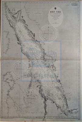
Part of CARTAS NÁUTICAS
Zona Geográfica: Mar Rojo
Aparecen a la izquierda las costas de Sudán, Abysinia, Egipto y Nubia; a la derecha las costas de Yemen, en la península Arábiga.
INSTITUTO HIDROGRÁFICO INGLATERRA