- ES EXPONAV CARTAS NÁUTICAS CCN-000220
- Item
- 1939
Part of CARTAS NÁUTICAS
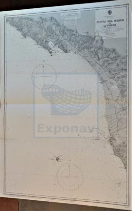
Zona Geográfica: Costa oeste de Italia. Mar Mediterráneo
Ciudades de Spezi y Livorno. Isla Gorgona
INSTITUTO HIDROGRÁFICO ITALIA
34 results with digital objects Show results with digital objects
Part of CARTAS NÁUTICAS
Zona Geográfica: Costa oeste de Italia. Mar Mediterráneo
Ciudades de Spezi y Livorno. Isla Gorgona
INSTITUTO HIDROGRÁFICO ITALIA
NORTH CHANNEL. MULL OF KINTYRE TO BELFAST LOUGH
Part of CARTAS NÁUTICAS
Zona Geográfica: Costa este de Irlanda
Aparece el Canal del Norte, costa del condado de Antrim
INSTITUTO HIDROGRÁFICO INGLATERRA
HARBOURS AND ANCHORAGES ON THE COAST OF HAITI AND THE DOMINICAN REPUBLIC
Part of CARTAS NÁUTICAS
Zona Geográfica: Mar Caribe
Contiene 11 recuadros con St. Nicolás Mole a 1:25000; Cayemites Bay a 1:147410; Navassa Island a 1:23280; Acul Bay a 1:53000; Romana River entrance a 1:12500; Gran Pierre Bay a 1:50000; Port Jackson a 1:25180; St. Marc Bay a 1:36640; Jacmel Bay a 1:29150; Port Plata a 1:10100 y Puerto de la ciudad de Trujillo a 1:13130
INSTITUTO HIDROGRÁFICO ESTADOS UNIDOS DE AMÉRICA
PUNTA DI MONTE GROSSO TO PUNTA BIANCA INCLUDING GOLFO DELLA SPEZIA
Part of CARTAS NÁUTICAS
Zona Geográfica: Costa oeste de Italia. Mar Mediterráneo
Aparece el golfo y la ciudad de Spezia. Isla Palmaria
INSTITUTO HIDROGRÁFICO ITALIA
Part of CARTAS NÁUTICAS
Zona Geográfica: Atlántico norte
Aparece la costa de Noruega y las islas Feroe
INSTITUTO HIDROGRÁFICO INGLATERRA
Part of CARTAS NÁUTICAS
Zona Geográfica: Costa oeste de Italia. Mar Mediterráneo
Aparece la isla de Giglio, promontorio Argentario, ciudad de Civitavecchia y Fiumicino
INSTITUTO HIDROGRÁFICO ITALIA
Part of CARTAS NÁUTICAS
Zona Geográfica: Mar del Norte
Costa de Noruega, islas Orkney en Escocia y las islas Shetland
INSTITUTO HIDROGRÁFICO INGLATERRA
ENGLISH CHANNEL. EASTERN PORTION
Part of CARTAS NÁUTICAS
Zona Geográfica: Canal de la Mancha
Aparece el Canal de la Mancha separando Inglaterra y Francia
INSTITUTO HIDROGRÁFICO INGLATERRA
THE NARROWS AND ST. GEORGE´S HARBOUR
Part of CARTAS NÁUTICAS
Zona Geográfica: Océano Atlántico norte. Islas Bermudas
Islas de St. George, Smith y David
INSTITUTO HIDROGRÁFICO INGLATERRA
ENGLISH CHANNEL. WESTERN SHEET. MILFORD HAVEN TO PLYMOUTH
Part of CARTAS NÁUTICAS
Zona Geográfica: Canal de la Mancha
Aparece las tierras de Pembroke y Cornwall
INSTITUTO HIDROGRÁFICO INGLATERRA