- ES EXPONAV CARTAS NÁUTICAS CCN-000256
- Item
- 1824
Part of CARTAS NÁUTICAS
Zona Geográfica: Martinica. Indias Occidentales.
Aparece la bahía y el puerto de Fort de France
INSTITUTO HIDROGRÁFICO FRANCIA
4 results with digital objects Show results with digital objects
Part of CARTAS NÁUTICAS
Zona Geográfica: Martinica. Indias Occidentales.
Aparece la bahía y el puerto de Fort de France
INSTITUTO HIDROGRÁFICO FRANCIA
NEW PROVIDENCE ISLAND. BAHAMAS ISLANDS
Part of CARTAS NÁUTICAS
Zona Geográfica: Indias Occidentales. Islas Bahamas
Aparece la isla de New Providence, el lago Killarney y la isla de Hog
INSTITUTO HIDROGRÁFICO INGLATERRA
Part of CARTAS NÁUTICAS
Zona Geográfica: Costa norte de Cuba. Indias Occidentales
Aparece el cayo Sabinal, bahía de Mayanabo.
INSTITUTO HIDROGRÁFICO ESTADOS UNIDOS DE AMÉRICA
Part of CARTAS NÁUTICAS
Zona Geográfica: Costa sur de Cuba. Indias Occidentales
Aparece el puerto de Cienfuegos y las ensenadas de Ramírez y Marsillan
INSTITUTO HIDROGRÁFICO ESTADOS UNIDOS DE AMÉRICA
Part of CARTAS NÁUTICAS
Zona Geográfica: Costa norte de Cuba. Indias Occidentales
Aparecen el cabo Maysi, great Inagua y Winward passage
INSTITUTO HIDROGRÁFICO ESTADOS UNIDOS DE AMÉRICA
Part of CARTAS NÁUTICAS
Zona Geográfica: Indias occidentales
Aparece la costa de Yucatán y Belice
INSTITUTO HIDROGRÁFICO INGLATERRA
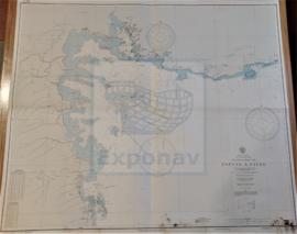
GUADELOUPE APPROACHES TO POINTE À PITRE
Part of CARTAS NÁUTICAS
Zona Geográfica: Guadalupe. Indias Occidentales
Aparece la ciudad de Pointre à Pitre y Petit Cul de Sac Marin
INSTITUTO HIDROGRÁFICO FRANCIA
Part of CARTAS NÁUTICAS
Zona Geográfica: Costa norte de Cuba. Indias Occidentales
Aparece la ciudad de Puerto Padre, las bahías de Puerto Padre y Guincho, puertos de Chaparra y Puerto Padre.
Incluye un recuadro con la entrada a Puerto Padre a escala 1:10000
INSTITUTO HIDROGRÁFICO ESTADOS UNIDOS DE AMÉRICA
BAHIAS NIPE, LEVISA AND CABONICO
Part of CARTAS NÁUTICAS
Zona Geográfica: Costa norte de Cuba. Indias Occidentales
Aparecen las bahías Levisa y Nipe, la península Ramon, y las ciudades de Antilla y Felton
INSTITUTO HIDROGRÁFICO ESTADOS UNIDOS DE AMÉRICA
PUERTO GIBARA TO CAYO MOA GRANDE
Part of CARTAS NÁUTICAS
Zona Geográfica: Costa norte de Cuba. Indias Occidentales
Aparecen las bahías Nipe y Banes, el puerto Gibara y cayo Moa Grande
INSTITUTO HIDROGRÁFICO ESTADOS UNIDOS DE AMÉRICA