NORTH CHANNEL. MULL OF KINTYRE TO BELFAST LOUGH
- ES EXPONAV CARTAS NÁUTICAS CCN-000207
- Item
- 1944
Part of CARTAS NÁUTICAS
Zona Geográfica: Costa este de Irlanda
Aparece el Canal del Norte, costa del condado de Antrim
INSTITUTO HIDROGRÁFICO INGLATERRA
5 results with digital objects Show results with digital objects
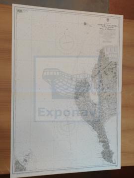
NORTH CHANNEL. MULL OF KINTYRE TO BELFAST LOUGH
Part of CARTAS NÁUTICAS
Zona Geográfica: Costa este de Irlanda
Aparece el Canal del Norte, costa del condado de Antrim
INSTITUTO HIDROGRÁFICO INGLATERRA
NORTH CHANNEL. SANDA ISLANS TO MULL OF GALLOWAY
Part of CARTAS NÁUTICAS
Zona Geográfica: Costa oeste de Escocia
Aparece el Canal del Norte, parte de la costa de Irlanda y Therinns en la isla Sanda
INSTITUTO HIDROGRÁFICO INGLATERRA
Part of CARTAS NÁUTICAS
Zona Geográfica: Escocia. Islas Orcadas
Aparecen las islas Orcadas en la costa norte de Escocia.
INSTITUTO HIDROGRÁFICO INGLATERRA
PRAWLE POINT TO HENGISTBURY HEAD
Part of CARTAS NÁUTICAS
Zona Geográfica: Costa sur de Inglaterra
Tierras de Devonshire, Dorsetchire, Hampshire y la bahía Lyme
INSTITUTO HIDROGRÁFICO INGLATERRA
Part of CARTAS NÁUTICAS
Zona Geográfica: Costa Oeste de África. Gambia
Costa de África correspondiente con la entrada del río Gambia.
INSTITUTO HIDROGRÁFICO INGLATERRA
Part of CARTAS NÁUTICAS
Zona Geográfica: Costa este de Inglaterra
Tierras de Northumberland, mar del Norte y el río Tyne
INSTITUTO HIDROGRÁFICO INGLATERRA
Part of CARTAS NÁUTICAS
Zona Geográfica: Costa Sur de Francia. Mar Mediterráneo
Plano de la costa de Marsella con un recuadro con el plano de la ciudad. Contiene tres vistas panorámicas.
INSTITUTO HIDROGRÁFICO INGLATERRA
Part of CARTAS NÁUTICAS
Zona Geográfica: Islas británicas
Islas Shetland (Mainland, Yell y Unst)
INSTITUTO HIDROGRÁFICO INGLATERRA
SOUTHERN APPROACH TO THE MINCH. COLONSAY TO NORTH POINT OF SKYE
Part of CARTAS NÁUTICAS
Zona Geográfica: Costa oeste de Escocia
Aparecen las islas de Skye, North Uist, South Uist, Tiree, Mull, Eigg y Rhum
INSTITUTO HIDROGRÁFICO INGLATERRA
SOUTHERN APPROACH TO THE MINCH. COLONSAY TO NORTH POINT OF SKYE
Part of CARTAS NÁUTICAS
Zona Geográfica: Costa oeste de Escocia
Aparecen las islas de Skye, North Uist, South Uist, Tiree, Mull, Eigg y Rhum
INSTITUTO HIDROGRÁFICO INGLATERRA