KILBRANNAN SOUND AND APPROACHES
- ES EXPONAV CARTAS NÁUTICAS CCN-000180
- Unidad documental simple
- 1947
Parte deCARTAS NÁUTICAS
Zona Geográfica: Costa oeste de Escocia
Aparece la península de Kintyre y la isla de Arran
INSTITUTO HIDROGRÁFICO INGLATERRA
5 resultados con objetos digitales Muestra los resultados con objetos digitales
KILBRANNAN SOUND AND APPROACHES
Parte deCARTAS NÁUTICAS
Zona Geográfica: Costa oeste de Escocia
Aparece la península de Kintyre y la isla de Arran
INSTITUTO HIDROGRÁFICO INGLATERRA
BRISTOL CHANNEL. WORMS HEAD TO WATCHET
Parte deCARTAS NÁUTICAS
Zona Geográfica: Costa oeste de Inglaterra
Canal de Bristol separando las tierras de Gower y Glamorgan de las tierras de Devonshire y Somerset
INSTITUTO HIDROGRÁFICO INGLATERRA
Parte deCARTAS NÁUTICAS
Zona Geográfica: Costa este de Inglaterra
Tierras de Northumberland, mar del Norte y el río Tyne
INSTITUTO HIDROGRÁFICO INGLATERRA
ISLAND OF LINNEY HEAD TO OXWICH POINT
Parte deCARTAS NÁUTICAS
Zona Geográfica: Costa sur de Gales
Aparecen las tierras de Pembrokeshire y Carmarthenshire. Bahía de Carmarthen
INSTITUTO HIDROGRÁFICO INGLATERRA
Parte deCARTAS NÁUTICAS
Zona Geográfica: Islas británicas
Islas Shetland (Mainland, Yell y Unst)
INSTITUTO HIDROGRÁFICO INGLATERRA
SUSA TO MAHEDIA WITH THE KURIAT ISLANDS
Parte deCARTAS NÁUTICAS
Zona Geográfica: Mar Mediterráneo. Túnez
Aparece el golfo de Monastir y las islas Kuriat.
Contiene una recuadro con el fondeadero de Monastir a escala 1:40400 y otro recuadro con el fondeadero de Mahedia a escala 1:40400
INSTITUTO HIDROGRÁFICO INGLATERRA
TREVOSE HEAD TO DODMAN POINT INCLUDING THE SCILLY ISLES
Parte deCARTAS NÁUTICAS
Zona Geográfica: Costa suroeste de Inglaterra
Aparecen las tierras de Cornwall y las islas Scilly
INSTITUTO HIDROGRÁFICO INGLATERRA
ARDNAMURCHAN TO SUMMER ISLES INCLUDING THE INNER CHANNEL AND THE MINCH
Parte deCARTAS NÁUTICAS
Zona Geográfica: Costa oeste de Escocia
Aparece la isla de Skye, la costa de Inverness, Ross, Cromarty, Harris y Lewis
INSTITUTO HIDROGRÁFICO INGLATERRA
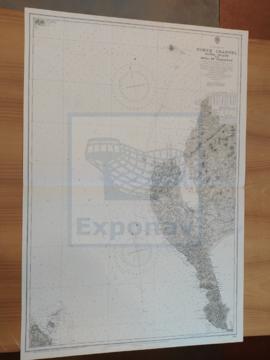
NORTH CHANNEL. SANDA ISLANS TO MULL OF GALLOWAY
Parte deCARTAS NÁUTICAS
Zona Geográfica: Costa oeste de Escocia
Aparece el Canal del Norte, parte de la costa de Irlanda y Therinns en la isla Sanda
INSTITUTO HIDROGRÁFICO INGLATERRA
NORTH CHANNEL. MULL OF KINTYRE TO BELFAST LOUGH
Parte deCARTAS NÁUTICAS
Zona Geográfica: Costa este de Irlanda
Aparece el Canal del Norte, costa del condado de Antrim
INSTITUTO HIDROGRÁFICO INGLATERRA