- ES EXPONAV CARTAS NÁUTICAS CCN-000089
- Item
- 1942
Part of CARTAS NÁUTICAS
Zona Geográfica: Costa Oeste de África. Gambia
Costa de África correspondiente con la entrada del río Gambia.
INSTITUTO HIDROGRÁFICO INGLATERRA
9 results with digital objects Show results with digital objects
Part of CARTAS NÁUTICAS
Zona Geográfica: Costa Oeste de África. Gambia
Costa de África correspondiente con la entrada del río Gambia.
INSTITUTO HIDROGRÁFICO INGLATERRA
Part of CARTAS NÁUTICAS
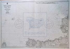
Zona Geográfica: Costa Norte de Escocia
Aparecen las islas Orkney, Mainland y Sutherland
INSTITUTO HIDROGRÁFICO INGLATERRA
DUNGENESS TO THE THAMES INCLUDING DOVER STRAIT
Part of CARTAS NÁUTICAS
Zona Geográfica: Inglaterra, costa Sur
Departamento de Calais (Francia), el estrecho de Dover y la costa de Kent (Inglaterra)
INSTITUTO HIDROGRÁFICO INGLATERRA
APPROACHES TO ALEXANDRÍA AND ABU QIR BAY
Part of CARTAS NÁUTICAS
Zona Geográfica: Egipto. Mar Mediterráneo
Aparece la bahía de Abu Qir, los lagos de Maryût y Idku.
Contiene un recuadro con el plano de la parte occidental de la bahía de Abu Qir
INSTITUTO HIDROGRÁFICO INGLATERRA
STRETTO DI MESINA AND APPROACHES
Part of CARTAS NÁUTICAS
Zona Geográfica: Costa Sur de Italia. Mar Mediterráneo
Sicilia, estrecho de Mesina y Calabria
INSTITUTO HIDROGRÁFICO ITALIA
Part of CARTAS NÁUTICAS
Zona Geográfica: Mar de Irlanda
Aparece la isla de Man. Contiene recuadros con las bahías de Castletown y Ramsey, el puerto de St. Mary, Calf Sound, Port Erin y Peel.
INSTITUTO HIDROGRÁFICO INGLATERRA

Part of CARTAS NÁUTICAS
Zona Geográfica: Inglaterra costa oeste
Proximidades del puerto de Liverpool desde la punta de Great Ormes a Southport con las entradas de los ríos Dee y Mersey y los puertos de Liverpool y Birkenhead
INSTITUTO HIDROGRÁFICO INGLATERRA
Part of CARTAS NÁUTICAS
Zona Geográfica: Mar de Irlanda. Canal de San Jorge
Canal de San Jorge con los puertos de Drogheda, Dublín, Wicklow y las islas de Holyhead y Lambay.
INSTITUTO HIDROGRÁFICO INGLATERRA
MECKLENBURGER BUCHT TO GREIFSWALDER BODDEN
Part of CARTAS NÁUTICAS
Zona Geográfica: Mar Báltico
Tierras de Pommern y Rügen. Contiene un recuadro con Warnemünde Hafen a escala 1:25000
INSTITUTO HIDROGRÁFICO DINAMARCA
FERMARN BELT AND MECKLENBURGER BUCHT
Part of CARTAS NÁUTICAS
Zona Geográfica: Mar Báltico
Tierras de Lloland, Fehmarn Belt, Scheleswig Holstein, Mecklenburg e la isla de Fehmarn.
Contiene recuadros de Wismar Bucht, Travemünde y Fehmarn Sound.
INSTITUTO HIDROGRÁFICO DINAMARCA