- ES EXPONAV CARTAS NÁUTICAS CCN-000138
- Item
- 1961
Part of CARTAS NÁUTICAS
Zona Geográfica: Francia costa norte
Costa norte de Francia con los puertos de Cherburgo y Le Havre
INSTITUTO HIDROGRÁFICO FRANCIA
9 results with digital objects Show results with digital objects
Part of CARTAS NÁUTICAS
Zona Geográfica: Francia costa norte
Costa norte de Francia con los puertos de Cherburgo y Le Havre
INSTITUTO HIDROGRÁFICO FRANCIA
HELGOLAND BIGHT AND APPROACHES
Part of CARTAS NÁUTICAS
Zona Geográfica: Mar del Norte. Alemania
Desembocadura del río Elba
INSTITUTO HIDROGRÁFICO ALEMANIA
PUNTA DELLA CHIAPPA TO PUNTA DI MONTE GROSSO
Part of CARTAS NÁUTICAS
Zona Geográfica: Mar Mediterráneo
Golfo Tigullio
INSTITUTO HIDROGRÁFICO ITALIA
Part of CARTAS NÁUTICAS
Zona Geográfica: Costa oeste de Escocia
Aparecen las islas de Islay y Jura; bahía de Laggan
INSTITUTO HIDROGRÁFICO INGLATERRA
Part of CARTAS NÁUTICAS
Zona Geográfica: Costa norte de Cuba. Indias Occidentales
Aparecen el cabo Maysi, great Inagua y Winward passage
INSTITUTO HIDROGRÁFICO ESTADOS UNIDOS DE AMÉRICA
PRAWLE POINT TO HENGISTBURY HEAD
Part of CARTAS NÁUTICAS
Zona Geográfica: Costa sur de Inglaterra
Tierras de Devonshire, Dorsetchire, Hampshire y la bahía Lyme
INSTITUTO HIDROGRÁFICO INGLATERRA
Part of CARTAS NÁUTICAS
Zona Geográfica: Costa este de Inglaterra
Tierras de Northumberland, mar del Norte y el río Tyne
INSTITUTO HIDROGRÁFICO INGLATERRA
PUERTO GIBARA TO CAYO MOA GRANDE
Part of CARTAS NÁUTICAS
Zona Geográfica: Costa norte de Cuba. Indias Occidentales
Aparecen las bahías Nipe y Banes, el puerto Gibara y cayo Moa Grande
INSTITUTO HIDROGRÁFICO ESTADOS UNIDOS DE AMÉRICA
Part of CARTAS NÁUTICAS
Zona Geográfica: Islas británicas
Islas Shetland (Mainland, Yell y Unst)
INSTITUTO HIDROGRÁFICO INGLATERRA
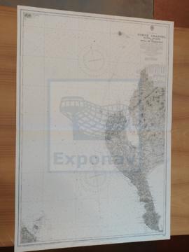
NORTH CHANNEL. SANDA ISLANS TO MULL OF GALLOWAY
Part of CARTAS NÁUTICAS
Zona Geográfica: Costa oeste de Escocia
Aparece el Canal del Norte, parte de la costa de Irlanda y Therinns en la isla Sanda
INSTITUTO HIDROGRÁFICO INGLATERRA