- ES EXPONAV CARTAS NÁUTICAS CCN-000213
- Item
- 1897
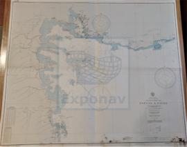
Part of CARTAS NÁUTICAS
Zona Geográfica: Costa oeste de Francia
Aparecen las tierras de Charente Inferieur y Gironde, separadas por el río Gironde
INSTITUTO HIDROGRÁFICO FRANCIA
2 results with digital objects Show results with digital objects
Part of CARTAS NÁUTICAS
Zona Geográfica: Costa oeste de Francia
Aparecen las tierras de Charente Inferieur y Gironde, separadas por el río Gironde
INSTITUTO HIDROGRÁFICO FRANCIA
HARBOURS AND ANCHORAGES ON THE COAST OF HAITI AND THE DOMINICAN REPUBLIC
Part of CARTAS NÁUTICAS
Zona Geográfica: Mar Caribe
Contiene 11 recuadros con St. Nicolás Mole a 1:25000; Cayemites Bay a 1:147410; Navassa Island a 1:23280; Acul Bay a 1:53000; Romana River entrance a 1:12500; Gran Pierre Bay a 1:50000; Port Jackson a 1:25180; St. Marc Bay a 1:36640; Jacmel Bay a 1:29150; Port Plata a 1:10100 y Puerto de la ciudad de Trujillo a 1:13130
INSTITUTO HIDROGRÁFICO ESTADOS UNIDOS DE AMÉRICA
Part of CARTAS NÁUTICAS
Zona Geográfica: Costa sur de Francia. Mar Mediterráneo
Aparece la ciudad de Marsella y el golfo de Fos.
Incluye un recuadro con el puerto de Bouc a escala 1:29160
INSTITUTO HIDROGRÁFICO FRANCIA
PUERTO CABELLO TO RIO ORINOCO AND THE LESSER ANTILLES TRINIDAD TO MARTINIQUE
Part of CARTAS NÁUTICAS
Zona Geográfica: Venezuela. América del Sur
Aparece el mar del Caribe, Venezuela, islas Windward y las islas de Trinidad y Tobago.
INSTITUTO HIDROGRÁFICO ESTADOS UNIDOS DE AMÉRICA
ANCHORAGES ON THE WEST COAST OF ÁFRICA
Part of CARTAS NÁUTICAS
Zona Geográfica: Costa oeste de África. Senegal
Contiene 4 recuadros: Rufisque Anchorage (Senegal) a 1:20000 (1875-1876); Portudal Anchorage (Senegal) a 1:30000 (1843); Dakar Road (Senegal) a 1:20000 (1930) y Joal Anchorage (Senegal) a 1:30000 (1910)
INSTITUTO HIDROGRÁFICO FRANCIA
Part of CARTAS NÁUTICAS
Zona Geográfica: Indias Occidentales
Aparece la isla Martinica
INSTITUTO HIDROGRÁFICO FRANCIA
Part of CARTAS NÁUTICAS
Zona Geográfica: Martinica. Indias Occidentales.
Aparece la bahía y el puerto de Fort de France
INSTITUTO HIDROGRÁFICO FRANCIA
SUEZ TO THE BROTHERS INCLUDING GULF OF 'AQABA
Part of CARTAS NÁUTICAS
Zona Geográfica: Mar Rojo
Aparece Arabia Saudí, la península de Sinaí, Egipto y golfo de Aqaba
INSTITUTO HIDROGRÁFICO INGLATERRA
Part of CARTAS NÁUTICAS
Zona Geográfica: Mar Rojo. Golfo de Aden
Aparece el golfo de Aden, el mar Rojo, sur de Arabia Saudí y parte de la costa de África
INSTITUTO HIDROGRÁFICO INGLATERRA
GUADELOUPE APPROACHES TO POINTE À PITRE
Part of CARTAS NÁUTICAS
Zona Geográfica: Guadalupe. Indias Occidentales
Aparece la ciudad de Pointre à Pitre y Petit Cul de Sac Marin
INSTITUTO HIDROGRÁFICO FRANCIA