- ES EXPONAV CARTAS NÁUTICAS CCN-000097
- Item
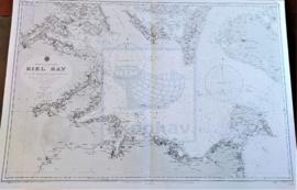
- 1911
Part of CARTAS NÁUTICAS
Zona Geográfica: Mar Báltico
Aparecen la bahía de Kiel y las tierras de Lolland, Holstein y la isla Fehmarn
INSTITUTO HIDROGRÁFICO ALEMANIA
1 results with digital objects Show results with digital objects
Part of CARTAS NÁUTICAS
Zona Geográfica: Mar Báltico
Aparecen la bahía de Kiel y las tierras de Lolland, Holstein y la isla Fehmarn
INSTITUTO HIDROGRÁFICO ALEMANIA
FERMARN BELT AND MECKLENBURGER BUCHT
Part of CARTAS NÁUTICAS
Zona Geográfica: Mar Báltico
Tierras de Lloland, Fehmarn Belt, Scheleswig Holstein, Mecklenburg e la isla de Fehmarn.
Contiene recuadros de Wismar Bucht, Travemünde y Fehmarn Sound.
INSTITUTO HIDROGRÁFICO DINAMARCA
MECKLENBURGER BUCHT TO GREIFSWALDER BODDEN
Part of CARTAS NÁUTICAS
Zona Geográfica: Mar Báltico
Tierras de Pommern y Rügen. Contiene un recuadro con Warnemünde Hafen a escala 1:25000
INSTITUTO HIDROGRÁFICO DINAMARCA
Part of CARTAS NÁUTICAS
Zona Geográfica: Mar Báltico
Aparecen las costas de Noruega, Suecia y Dinamarca. Las tierras de Jutlandia. Isla de Fyen
INSTITUTO HIDROFRÁFICO NORUEGA
Part of CARTAS NÁUTICAS
Zona Geográfica: Mar Báltico
Aparece el mar Báltico con la isla Gotland en el centro. Costas de Polonia, Lituania, Letonia, Estonia y Suecia.
INSTITUTO HIDROGRÁFICO ALEMANIA