- ES EXPONAV CARTAS NÁUTICAS CCN-000071
- Item
- 1944
Part of CARTAS NÁUTICAS
Zona Geográfica: Océano Atlántico
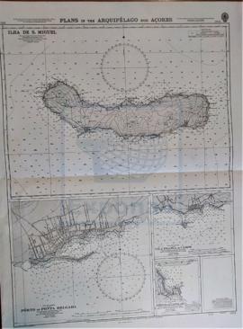
Recuadro con la isla de San Miguel
INSTITUTO HIDROGRÁFICO INGLATERRA
5 results with digital objects Show results with digital objects
Part of CARTAS NÁUTICAS
Zona Geográfica: Océano Atlántico
Recuadro con la isla de San Miguel
INSTITUTO HIDROGRÁFICO INGLATERRA
Part of CARTAS NÁUTICAS
Zona Geográfica: Costa Sur de Inglaterra
Costa de Inglaterra desde Dodman hasta Start, con la ciudad de Plymouth y un recuadro con las rocas de Eddystone
INSTITUTO HIDROGRÁFICO INGLATERRA
APPROACHES TO THE BRISTOL CHANNEL
Part of CARTAS NÁUTICAS
Zona Geográfica: Costa Oeste de Inglaterra
Carta que representa los alrededores del canal de Bristol
INSTITUTO HIDROGRÁFICO INGLATERRA
Part of CARTAS NÁUTICAS
Zona Geográfica: República Dominicana
Plano de la costa y la bahía de Santo Domingo. Recuadros con las costas del puerto de Trujillo, de San Pedro de Marcorís, el puerto de San Andrés y río Romana.
INSTITUTO HIDROGRÁFICO INGLATERRA
MULL OF KINTYRE TO ARDNAMURCHAN
Part of CARTAS NÁUTICAS
Zona Geográfica: Costa Oeste de Escocia
Aparece la isla de Arran, la península de Kintyre y las tierras de Islay y Jura.
INSTITUTO HIDROGRÁFICO INGLATERRA
CARNSORE POINT TO BRAICH-Y-PWLL
Part of CARTAS NÁUTICAS
Zona Geográfica: Canal de San Jorge
Plano del canal de San Jorge y la bahía de Cardigan con las ciudades de Pembrokeshire y Merionetshire.
INSTITUTO HIDROGRÁFICO INGLATERRA
HEBRIDES OR WESTERN ISLES FROM BARRA HEAD TO SCARPA ISLAND
Part of CARTAS NÁUTICAS
Zona Geográfica: Costa oeste de Escocia
Aparecen las tierras de Harris, Lewis, North Uist, Nenbecula y South Uist
INSTITUTO HIDROGRÁFICO INGLATERRA
Part of CARTAS NÁUTICAS
Zona Geográfica: Mar del Norte
Tierras de Kadzan, Walcheren, Goeree, Schouwen, Beveland, Tolen...
INSTITUTO HIDROGRÁFICO INGLATERRA
Part of CARTAS NÁUTICAS
Zona Geográfica: Escocia. Islas Orcadas
Aparecen las islas Orcadas en la costa norte de Escocia.
INSTITUTO HIDROGRÁFICO INGLATERRA
SUSA TO MAHEDIA WITH THE KURIAT ISLANDS
Part of CARTAS NÁUTICAS
Zona Geográfica: Mar Mediterráneo. Túnez
Aparece el golfo de Monastir y las islas Kuriat.
Contiene una recuadro con el fondeadero de Monastir a escala 1:40400 y otro recuadro con el fondeadero de Mahedia a escala 1:40400
INSTITUTO HIDROGRÁFICO INGLATERRA