- ES EXPONAV CARTAS NÁUTICAS CCN-000062
- Item
- 1951
Part of CARTAS NÁUTICAS
Zona Geográfica: Costa Oeste de Escocia
Vista del Mar de Hebrides, en concreto de Little Minch. Aparecen las islas de Skye y Harris.
INSTITUTO HIDROGRÁFICO INGLATERRA
5 results with digital objects Show results with digital objects
Part of CARTAS NÁUTICAS
Zona Geográfica: Costa Oeste de Escocia
Vista del Mar de Hebrides, en concreto de Little Minch. Aparecen las islas de Skye y Harris.
INSTITUTO HIDROGRÁFICO INGLATERRA
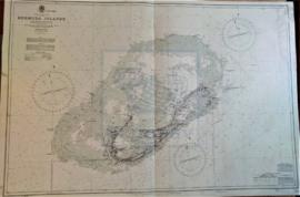
Part of CARTAS NÁUTICAS
Zona Geográfica: Océano Atlántico Norte
Plano de las islas Bermudas con sus principales puertos e islas.
INSTITUTO HIDROGRÁFICO INGLATERRA

Part of CARTAS NÁUTICAS
Zona Geográfica: Inglaterra costa oeste
Proximidades del puerto de Liverpool desde la punta de Great Ormes a Southport con las entradas de los ríos Dee y Mersey y los puertos de Liverpool y Birkenhead
INSTITUTO HIDROGRÁFICO INGLATERRA
CAPE SIERRA LEONO TO TURTLE ISLANDS
Part of CARTAS NÁUTICAS
Zona Geográfica: Costa oeste de África
Proximidades de Sierra Leona y Sherbo. Puerto de Freetown y las islas Banana y Tortuga
INSTITUTO HIDROGRÁFICO INGLATERRA
Part of CARTAS NÁUTICAS
Zona Geográfica: Costa Oeste de África. Liberia
Costa de África en la zona de Liberia desde el río Junk hasta la bahía de Cestos. Aparecen los montes Tobacco y Table. Contiene un recuadro con la bahía de Gran Bassa.
INSTITUTO HIDROGRÁFICO INGLATERRA
ISLANDS IN THE SOUTHERN PORTION OF THE RED SEA
Part of CARTAS NÁUTICAS
Zona Geográfica: Mar Rojo
Contiene 3 recuadros con: Zubair island a escala 1:96800; Zuqar island y Hanish islands a escala 1: 96600 y Abu'Ali Channel a escala 1:36950
INSTITUTO HIDROGRÁFICO INGLATERRA
Part of CARTAS NÁUTICAS
Zona Geográfica: Costa oeste de Inglaterra
Aparecen las tierras de Cumberland, Dumfries y Kirkcudbright.
INSTITUTO HIDROGRÁFICO INGLATERRA
Part of CARTAS NÁUTICAS
Zona Geográfica: Costa oeste de Inglaterra
Aparecen las tierras de Cumberland, Dumfries y Kirkcudbright.
INSTITUTO HIDROGRÁFICO INGLATERRA
Part of CARTAS NÁUTICAS
Zona Geográfica: Mar Rojo
Golfo de Suez
INSTITUTO HIDROGRÁFICO INGLATERRA
SOUTHERN APPROACH TO THE MINCH. COLONSAY TO NORTH POINT OF SKYE
Part of CARTAS NÁUTICAS
Zona Geográfica: Costa oeste de Escocia
Aparecen las islas de Skye, North Uist, South Uist, Tiree, Mull, Eigg y Rhum
INSTITUTO HIDROGRÁFICO INGLATERRA