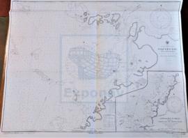
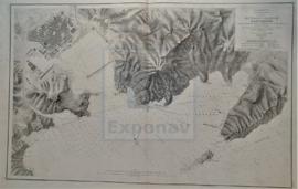
portulano

Taxonomía

Código

Nota(s) sobre el alcance

Nota(s) sobre el origen

Mostrar nota(s)

Términos jerárquicos

portulano

Términos equivalentes

portulano

Términos asociados

portulano

38 Descripción archivística results for portulano

38 resultados directamente relacionados Excluir términos relacionados

EAST LOCH TARBERT

  • ES EXPONAV CARTAS NÁUTICAS CCN-000147
  • Unidad documental simple
  • 1857
  • Parte deCARTAS NÁUTICAS

Zona Geográfica: Costa oeste de Escocia. Islas Hébridas
Contiene los canales de Scalpay y Braich More. Aparecen las islas de Scalpay, Scotasay, Glorigs, Rossay.

INSTITUTO HIDROGRÁFICO INGLATERRA

ENTRANCE TO CIENFUEGOS BAY

  • ES EXPONAV CARTAS NÁUTICAS CCN-000271
  • Unidad documental simple
  • 1902
  • Parte deCARTAS NÁUTICAS

Zona Geográfica: Costa sur de Cuba. Indias Occidentales
Aparecen el cayo de Carenas, punta de Pasacaballos, punta de la Sabanilla y punta de los Colorados

INSTITUTO HIDROGRÁFICO ESTADOS UNIDOS DE AMÉRICA

HARBOUR OF ST. THOMAS

  • ES EXPONAV CARTAS NÁUTICAS CCN-000258
  • Unidad documental simple
  • 1918
  • Parte deCARTAS NÁUTICAS

Zona Geográfica: Indias Occidentales
Isla de St. Thomas con la ciudad de Charlotte Amalie. Aparecen las islas Hassel y Water

INSTITUTO HIDROGRÁFICO ESTADOS UNIDOS DE AMÉRICA

HARBOURS AND ANCHORAGES ON THE COAST OF HAITI AND THE DOMINICAN REPUBLIC

  • ES EXPONAV CARTAS NÁUTICAS CCN-000221
  • Unidad documental simple
  • 1895
  • Parte deCARTAS NÁUTICAS

Zona Geográfica: Mar Caribe
Contiene 11 recuadros con St. Nicolás Mole a 1:25000; Cayemites Bay a 1:147410; Navassa Island a 1:23280; Acul Bay a 1:53000; Romana River entrance a 1:12500; Gran Pierre Bay a 1:50000; Port Jackson a 1:25180; St. Marc Bay a 1:36640; Jacmel Bay a 1:29150; Port Plata a 1:10100 y Puerto de la ciudad de Trujillo a 1:13130

INSTITUTO HIDROGRÁFICO ESTADOS UNIDOS DE AMÉRICA

LOCH SKIPORT

  • ES EXPONAV CARTAS NÁUTICAS CCN-000128
  • Unidad documental simple
  • 1863
  • Parte deCARTAS NÁUTICAS

Zona Geográfica: Sureste de Escocia. Islas Hébridas
Aparecen las islas de Ornish y Shillay More.

INSTITUTO HIDROGRÁFICO INGLATERRA

LOCHS ERISORT, LEURBOST AND GRIMSHADER

  • ES EXPONAV CARTAS NÁUTICAS CCN-000131
  • Unidad documental simple
  • 1848
  • Parte deCARTAS NÁUTICAS

Zona Geográfica: Costa oeste de Escocia
Contiene un recuadro con el lago Erisort y las entradas a Leurbost y Erisort

INSTITUTO HIDROGRÁFICO INGLATERRA

NIQUERO BAY AND APPROACHES

  • ES EXPONAV CARTAS NÁUTICAS CCN-000241
  • Unidad documental simple
  • 1907
  • Parte deCARTAS NÁUTICAS

Zona Geográfica: Costa sur de Cuba. Indias Occidentales
Aparece la bahía de Niquero. Contiene un recuadro con las cercanías a Beliz incluyendo la bahía Guanito y el río Limones a escala 1:24321

INSTITUTO HIDROGRÁFICO ESTADOS UNIDOS DE AMÉRICA

PLANO DE LA RADA Y PUERTO DE TARRAGONA

  • ES EXPONAV CARTAS NÁUTICAS CCN-000016
  • Unidad documental simple
  • 1880
  • Parte deCARTAS NÁUTICAS

Zona Geográfica: Costa oriental España
Torre de la catedral de Tarragona, faro del Morro del dique de levante

INSTITUTO HIDROGRÁFICO ESPAÑA

Resultados 11 a 20 de 38