- ES EXPONAV CARTAS NÁUTICAS CCN-000256
- Unidad documental simple
- 1824
Parte deCARTAS NÁUTICAS
Zona Geográfica: Martinica. Indias Occidentales.
Aparece la bahía y el puerto de Fort de France
INSTITUTO HIDROGRÁFICO FRANCIA
38 resultados directamente relacionados Excluir términos relacionados
Parte deCARTAS NÁUTICAS
Zona Geográfica: Martinica. Indias Occidentales.
Aparece la bahía y el puerto de Fort de France
INSTITUTO HIDROGRÁFICO FRANCIA
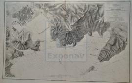
PLANO DEL PUERTO Y ARSENAL DE CARTAGENA CON LA ENSENADA DE ESCOMBRERA Y LAS ALGAMECAS
Parte deCARTAS NÁUTICAS
Zona Geográfica: Costa SE de España
Plano del puerto y arsenal de Cartagena, islote de Escombrera
INSTITUTO HIDROGRÁFICO ESPAÑA
ANCHORAGES ON THE WEST COAST OF ÁFRICA
Parte deCARTAS NÁUTICAS
Zona Geográfica: Costa oeste de África. Senegal
Contiene 4 recuadros: Rufisque Anchorage (Senegal) a 1:20000 (1875-1876); Portudal Anchorage (Senegal) a 1:30000 (1843); Dakar Road (Senegal) a 1:20000 (1930) y Joal Anchorage (Senegal) a 1:30000 (1910)
INSTITUTO HIDROGRÁFICO FRANCIA
Parte deCARTAS NÁUTICAS
Zona Geográfica: Costa este de Inglaterra
Aparece la bahía de Tees y el puente Victoria a la misma escala
INSTITUTO HIDROGRÁFICO INGLATERRA
HARBOURS AND ANCHORAGES ON THE COAST OF HAITI AND THE DOMINICAN REPUBLIC
Parte deCARTAS NÁUTICAS
Zona Geográfica: Mar Caribe
Contiene 11 recuadros con St. Nicolás Mole a 1:25000; Cayemites Bay a 1:147410; Navassa Island a 1:23280; Acul Bay a 1:53000; Romana River entrance a 1:12500; Gran Pierre Bay a 1:50000; Port Jackson a 1:25180; St. Marc Bay a 1:36640; Jacmel Bay a 1:29150; Port Plata a 1:10100 y Puerto de la ciudad de Trujillo a 1:13130
INSTITUTO HIDROGRÁFICO ESTADOS UNIDOS DE AMÉRICA
Parte deCARTAS NÁUTICAS
Zona Geográfica: Costa oeste de Inglaterra- Bahía de Morecambe
Aparece el puerto de Barrow
INSTITUTO HIDROGRÁFICO INGLATERRA
Parte deCARTAS NÁUTICAS
Zona Geográfica: Costa sur de Irlanda
Aparece Great Island, Spike island y Haulbowline island
INSTITUTO HIDROGRÁFICO INGLATERRA
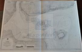
Parte deCARTAS NÁUTICAS
Zona Geográfica: Costa sur de Cuba. Indias Occidentales
Aparece el puerto de Cienfuegos y las ensenadas de Ramírez y Marsillan
INSTITUTO HIDROGRÁFICO ESTADOS UNIDOS DE AMÉRICA
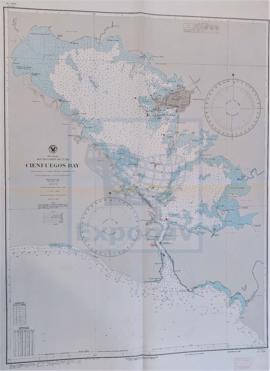
Parte deCARTAS NÁUTICAS
Zona Geográfica: Costa sur de Cuba. Indias Occidentales
Aparece la ciudad y la bahía de Cienfuegos
INSTITUTO HIDROGRÁFICO ESTADOS UNIDOS DE AMÉRICA
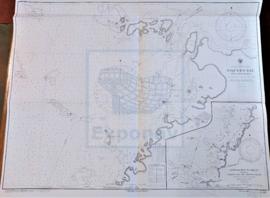
Parte deCARTAS NÁUTICAS
Zona Geográfica: Costa sur de Cuba. Indias Occidentales
Aparece la bahía de Niquero. Contiene un recuadro con las cercanías a Beliz incluyendo la bahía Guanito y el río Limones a escala 1:24321
INSTITUTO HIDROGRÁFICO ESTADOS UNIDOS DE AMÉRICA