- ES EXPONAV CARTAS NÁUTICAS CCN-000236
- Unidad documental simple
- 1852
Parte deCARTAS NÁUTICAS
Zona Geográfica: Costa oeste de Escocia
Aparecen las islas de Islay y Jura; bahía de Laggan
INSTITUTO HIDROGRÁFICO INGLATERRA
1716 resultados con objetos digitales Muestra los resultados con objetos digitales
Parte deCARTAS NÁUTICAS
Zona Geográfica: Costa oeste de Escocia
Aparecen las islas de Islay y Jura; bahía de Laggan
INSTITUTO HIDROGRÁFICO INGLATERRA
Parte deCARTAS NÁUTICAS
Zona Geográfica: Costa Este de Escocia
Tierras de Haddington, Fife y Augus
INSTITUTO HIDROGRÁFICO INGLATERRA
CAPE WRATH TO THE FLANNAN ISLES
Parte deCARTAS NÁUTICAS
Zona Geográfica: Costa norte de Escocia
Aparecen las tierras de Lewis y las tierras de Sutherland y Cromarty separadas por el North Minch
INSTITUTO HIDROGRÁFICO INGLATERRA
ISLE OF SKYE NORTHWARD OF LOCH EYNORT & SOUND OF SLEAT WITH ADJACENT SOUNDS & LOCHS TO THE EASTWARD
Parte deCARTAS NÁUTICAS
Zona Geográfica: Escocia costa oeste
Aparece la isla de Skye y la costa de Ross
INSTITUTO HIDROGRÁFICO INGLATERRA
Parte deCARTAS NÁUTICAS
Zona Geográfica: Indias occidentales. Caribe
Contiene el extremo este de Santo Domingo, la isla de Puerto Rico, las islas Vírgenes, Antigua, Barbuda, Guadalupe, María Galante, Montserrat, etc.
INSTITUTO HIDROGRÁFICO ESTADOS UNIDOS DE AMÉRICA
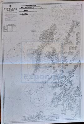
Parte deCARTAS NÁUTICAS
Zona Geográfica: costa oeste de Escocia
Costa oeste de Escocia con las islas de Lewis, Uist, Barra, Coll, Tiree, Islay, Jura, Tory y Arran
INSTITUTO HIDROGRÁFICO INGLATERRA
Parte deCARTAS NÁUTICAS
Zona Geográfica: África
Aparece la bahía y ciudad de Algeria y la región de Mitidja.
INSTITUTO HIDROGRÁFICO FRANCIA
Parte deCARTAS NÁUTICAS
Zona Geográfica: Entre Argelia y Cherchel. Mar Mediterráneo
Aparece la llanura de Mitidja y las ciudades de Argel y Cherchel
INSTITUTO HIDROGRÁFICO FRANCIA
Parte deCARTAS NÁUTICAS
Zona Geográfica: África costa norte
Aparecen las tierras de Beni Hidja, Beni Zioui, Beni Mnacer, Beni Zatyma, Beni Ali.
Incluye una vista de la costa
INSTITUTO HIDROGRÁFICO FRANCIA
Parte deCARTAS NÁUTICAS
Zona Geográfica: Mar Mediterráneo. Algeria
Aparecen las costas de Algeria y Constantine
INSTITUTO HIDROGRÁFICO INGLATERRA