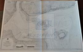
APPROACHES TO LIVERPOOL
Añadir al portapapeles
ES EXPONAV CARTAS NÁUTICAS CCN-000094
Unidad documental simple
1957
Parte deCARTAS NÁUTICAS
Zona Geográfica: Costa Oeste de Inglaterra
INSTITUTO HIDROGRÁFICO INGLATERRA
BARROW HARBOUR
Añadir al portapapeles
ES EXPONAV CARTAS NÁUTICAS CCN-000160
Unidad documental simple
1899
Parte deCARTAS NÁUTICAS
Zona Geográfica: Costa oeste de Inglaterra- Bahía de Morecambe
INSTITUTO HIDROGRÁFICO INGLATERRA
COBH
Añadir al portapapeles
ES EXPONAV CARTAS NÁUTICAS CCN-000157
Unidad documental simple
1902
Parte deCARTAS NÁUTICAS
Zona Geográfica: Costa sur de Irlanda
INSTITUTO HIDROGRÁFICO INGLATERRA
EAST LOCH TARBERT
Añadir al portapapeles
ES EXPONAV CARTAS NÁUTICAS CCN-000147
Unidad documental simple
1857
Parte deCARTAS NÁUTICAS
Zona Geográfica: Costa oeste de Escocia. Islas Hébridas
INSTITUTO HIDROGRÁFICO INGLATERRA
LOCH SKIPORT
Añadir al portapapeles
ES EXPONAV CARTAS NÁUTICAS CCN-000128
Unidad documental simple
1863
Parte deCARTAS NÁUTICAS
Zona Geográfica: Sureste de Escocia. Islas Hébridas
INSTITUTO HIDROGRÁFICO INGLATERRA
LOCHS ERISORT, LEURBOST AND GRIMSHADER
Añadir al portapapeles
ES EXPONAV CARTAS NÁUTICAS CCN-000131
Unidad documental simple
1848
Parte deCARTAS NÁUTICAS
Zona Geográfica: Costa oeste de Escocia
INSTITUTO HIDROGRÁFICO INGLATERRA
PLANS ON THE SOUTH COAST OF WALES
Añadir al portapapeles
ES EXPONAV CARTAS NÁUTICAS CCN-000132
Unidad documental simple
1949
Parte deCARTAS NÁUTICAS
Zona Geográfica: Islas Británicas
INSTITUTO HIDROGRÁFICO INGLATERRA
RIVER TYNE ENTRANCE
Añadir al portapapeles
ES EXPONAV CARTAS NÁUTICAS CCN-000095
Unidad documental simple
1892
Parte deCARTAS NÁUTICAS
Zona Geográfica: Costa Este de Inglaterra
INSTITUTO HIDROGRÁFICO INGLATERRA
TEES BAY
Añadir al portapapeles
ES EXPONAV CARTAS NÁUTICAS CCN-000198
Unidad documental simple
1891
Parte deCARTAS NÁUTICAS
Zona Geográfica: Costa este de Inglaterra
INSTITUTO HIDROGRÁFICO INGLATERRA
THE NARROWS AND ST. GEORGE´S HARBOUR
Añadir al portapapeles
ES EXPONAV CARTAS NÁUTICAS CCN-000210
Unidad documental simple
1922
Parte deCARTAS NÁUTICAS
Zona Geográfica: Océano Atlántico norte. Islas Bermudas
INSTITUTO HIDROGRÁFICO INGLATERRA