Identity area
Reference code
ES EXPONAV CARTAS NÁUTICAS CCN-000002
Title
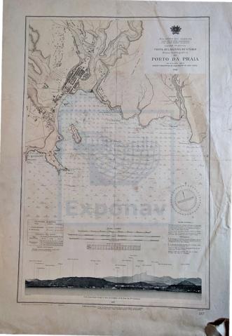
PLANO HIDROGRÁFICO DO PORTO DA PRAIA
Date(s)
- 1946 (Accumulation)
Level of description
Item
Extent and medium
1 carta náutica
Escala 1:10.000
Tamaño 77 x 54 cm.
Col.
Context area
Name of creator
Biographical history
Repository
Archival history
Immediate source of acquisition or transfer
Content and structure area
Scope and content
Zona Geográfica: Costa Sul da Ilha de Santiago
Costas sur de la Isla de Santiago con la entrada del puerto da Praia y una vista panorámica levantada desde 1,1 millas al E. del faro de punta tenebrosa editada por el Ministerio de las Colonias.
Appraisal, destruction and scheduling
Accruals
System of arrangement
Conditions of access and use area
Conditions governing access
Conditions governing reproduction
Language of material
- Portuguese
Script of material
Language and script notes
Physical characteristics and technical requirements
Material de la carta náutica en papel grueso
Estado de conservación Bueno
Finding aids
Allied materials area
Existence and location of originals
PLANERA 16
CAJÓN 1
Existence and location of copies
Related units of description
Notes area
Note
Lleva una tabla de las coordenadas geográficas y otra de las constantes de marea
Note
Número de carta: 267
Alternative identifier(s)
Access points
Subject access points
Place access points
Name access points
Genre access points
Description control area
Description identifier
Institution identifier
Rules and/or conventions used
Status
Level of detail
Dates of creation revision deletion
Language(s)
Script(s)
Sources
Digital object metadata
Filename
000002_PORTO_DA_PRAIA.pdf
Latitude
Longitude
Media type
Text
Mime-type
application/pdf
Filesize
2.9 MiB
Uploaded
November 19, 2020 1:44 AM